IMAGES TAKEN NEAR TO
Littleworth, FARINGDON, SN7 8JR
Introduction
This page details the photographs taken nearby to SN7 8JR by members of the Geograph project.
The Geograph project started in 2005 with the aim of publishing, organising and preserving representative images for every square kilometre of Great Britain, Ireland and the Isle of Man.

There are currently over 7.5m images from over14,400 individuals and you can help contribute to the project by visiting https://www.geograph.org.uk
Image Map
Images are licensed for reuse under creativecommons.org/licenses/by-sa/2.0
Notes
- Clicking on the map will re-center to the selected point.
- The higher the marker number, the further away the image location is from the centre of the postcode.
Image Listing (12 Images Found)
Images are licensed for reuse under creativecommons.org/licenses/by-sa/2.0
Image
Details
Distance
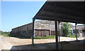
2
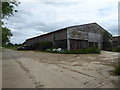
Barn, Brixton Farm
The bottom of the barn is made of railway sleepers.
Image: © Vieve Forward
Taken: 1 Jul 2019
0.05 miles
3
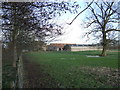
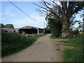
Brixton or Thrupp Farm?
Depends whether you go by the Landranger or Explorer maps.
Image: © Jonathan Billinger
Taken: 10 Jan 2007
0.07 miles
4
Path and drive at Thrupp Farm
Path and drive from Pucketty Cottage at Thrupp Farm
Image: © Shaun Ferguson
Taken: 5 Sep 2012
0.07 miles
5
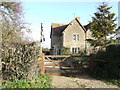
Spotted Cow Cottages
Backing on to the Upper Thames marshes.
Image: © Jonathan Billinger
Taken: 10 Jan 2007
0.15 miles
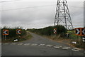
6
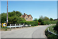
Thrupp Turn
Two straight stretches of road meet here at a right angle bend by Spotted Cow Cottages.
Image: © Des Blenkinsopp
Taken: 28 May 2020
0.19 miles
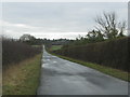
7
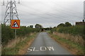
Approaching a sharp bend
On the road from Thrupp to Littleworth.
Image: © andrew auger
Taken: 3 Oct 2009
0.19 miles
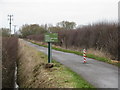
9
Footpath to Radcot Lock
From the Thrupp to Littleworth. According to the sign it is 1/2 mile to Radcot Lock from here.
Image: © andrew auger
Taken: 3 Oct 2009
0.19 miles