IMAGES TAKEN NEAR TO
Buckland, FARINGDON, SN7 8JL
Introduction
This page details the photographs taken nearby to SN7 8JL by members of the Geograph project.
The Geograph project started in 2005 with the aim of publishing, organising and preserving representative images for every square kilometre of Great Britain, Ireland and the Isle of Man.

There are currently over 7.5m images from over14,400 individuals and you can help contribute to the project by visiting https://www.geograph.org.uk
Image Map
Images are licensed for reuse under creativecommons.org/licenses/by-sa/2.0
Notes
- Clicking on the map will re-center to the selected point.
- The higher the marker number, the further away the image location is from the centre of the postcode.
Image Listing (13 Images Found)
Images are licensed for reuse under creativecommons.org/licenses/by-sa/2.0
Image
Details
Distance
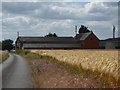
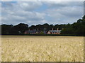
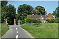
5
Barcote Lane
Heading straight for the gates of Barcote Park, a private estate.
Image: © Robin Webster
Taken: 18 May 2014
0.10 miles
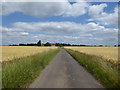
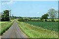
6
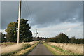
Heading for the A420
On an unclassified road from Hatford
Image: © andrew auger
Taken: 13 Oct 2008
0.14 miles
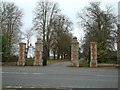
8
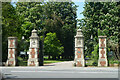
Gateway, Barcote Park
A misleading 'Private' sign for some, as a public bridleway extends part-way up the drive. The 1876 gateway is grade II listed.
Image: © Robin Webster
Taken: 18 May 2014
0.23 miles
9
Gates and lodge, Barcote Park
Leading principally to Barcote Farm and Manor.
Image: © Robin Webster
Taken: 18 May 2014
0.23 miles