IMAGES TAKEN NEAR TO
The Pines, FARINGDON, SN7 8AX
Introduction
This page details the photographs taken nearby to The Pines, SN7 8AX by members of the Geograph project.
The Geograph project started in 2005 with the aim of publishing, organising and preserving representative images for every square kilometre of Great Britain, Ireland and the Isle of Man.

There are currently over 7.5m images from over14,400 individuals and you can help contribute to the project by visiting https://www.geograph.org.uk
Image Map
Images are licensed for reuse under creativecommons.org/licenses/by-sa/2.0
Notes
- Clicking on the map will re-center to the selected point.
- The higher the marker number, the further away the image location is from the centre of the postcode.
Image Listing (34 Images Found)
Images are licensed for reuse under creativecommons.org/licenses/by-sa/2.0
Image
Details
Distance
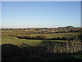
2
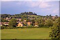
Looking over Faringdon towards the folly
Image: © Steve Daniels
Taken: 17 Aug 2010
0.09 miles
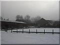
4
View over the fields towards Faringdon
From the B4019 Highworth road a little to the west of Faringdon.
Image: © andrew auger
Taken: 20 Dec 2009
0.18 miles
6
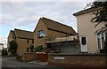
New and old housing on Coxwell Road, Faringdon
Image: © David Howard
Taken: 10 Sep 2019
0.19 miles
7
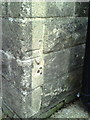
Benchmark on #2 Marlborough Gardens
Ordnance Survey cut mark benchmark described on the Bench Mark Database at http://www.bench-marks.org.uk/bm35699
Image: © Roger Templeman
Taken: 9 Oct 2010
0.20 miles
8
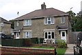
Nos. 2 and 4 Marlborough Gardens
There is an OS benchmark Image on the side of the right hand house where the wooden gate abuts
Image: © Roger Templeman
Taken: 18 Oct 2013
0.20 miles
9
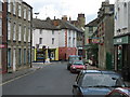
Marlborough Street looking towards Cornmarket
Image: © Jon S
Taken: 29 Sep 2005
0.21 miles