IMAGES TAKEN NEAR TO
Rawdon Way, FARINGDON, SN7 7YT
Introduction
This page details the photographs taken nearby to Rawdon Way, SN7 7YT by members of the Geograph project.
The Geograph project started in 2005 with the aim of publishing, organising and preserving representative images for every square kilometre of Great Britain, Ireland and the Isle of Man.

There are currently over 7.5m images from over14,400 individuals and you can help contribute to the project by visiting https://www.geograph.org.uk
Image Map
Images are licensed for reuse under creativecommons.org/licenses/by-sa/2.0
Notes
- Clicking on the map will re-center to the selected point.
- The higher the marker number, the further away the image location is from the centre of the postcode.
Image Listing (11 Images Found)
Images are licensed for reuse under creativecommons.org/licenses/by-sa/2.0
Image
Details
Distance
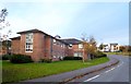
2
Folly Park, Faringdon
A sizable new housing development on the edge of town. Named after Faringdon Folly, a hilltop tower just to the north.
Image: © Des Blenkinsopp
Taken: 18 Nov 2012
0.09 miles
3
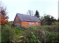
Old Pump House, Sands Hill
This was once a water pumping station, then a small local depot, but it has been disused for many years now. It used to belong to Thames Water, maybe still does.
Image: © Des Blenkinsopp
Taken: 18 Nov 2012
0.15 miles
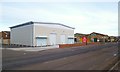
4
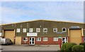
Industrial units on Park Road, Faringdon
Image: © David Howard
Taken: 23 Mar 2019
0.16 miles
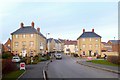
5
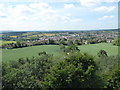
The view from Faringdon Folly 5: SW
With Faringdon in the middle distance, and the line of the Downs on the left horizon.
Image: © Vieve Forward
Taken: 7 Jul 2019
0.17 miles
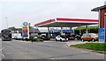
7
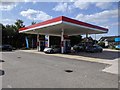
Service station on the A417, Park Road, Faringdon
Image: © Rob Purvis
Taken: 12 Sep 2020
0.17 miles
8
New Units To Let
Recent addition to the area of business premises that were built on the site of the old railway yard.
Image: © Des Blenkinsopp
Taken: 18 Nov 2012
0.18 miles
9
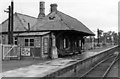
Faringdon station,1950
View SE, towards Uffington: terminus of ex-GWR branch from the main line there, closed to passengers 29/12/51, goods 1/7/63.
Image: © Walter Dendy, deceased
Taken: 24 Sep 1950
0.21 miles
10
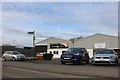
Industrial units on Park Road, Faringdon
Thanks to my efforts Old Dairy Classics on the right will soon have its own entry on Google Maps
Image: © David Howard
Taken: 23 Mar 2019
0.21 miles