IMAGES TAKEN NEAR TO
Richings Place, SN7 7QQ
Introduction
This page details the photographs taken nearby to Richings Place, SN7 7QQ by members of the Geograph project.
The Geograph project started in 2005 with the aim of publishing, organising and preserving representative images for every square kilometre of Great Britain, Ireland and the Isle of Man.

There are currently over 7.5m images from over14,400 individuals and you can help contribute to the project by visiting https://www.geograph.org.uk
Image Map (Loading...)


Getting Data...Please wait
Leaflet Map data © OpenStreetMap
Images are licensed for reuse under creativecommons.org/licenses/by-sa/2.0
Notes
- Clicking on the map will re-center to the selected point.
- The higher the marker number, the further away the image location is from the centre of the postcode.
Image Listing (14 Images Found)
Images are licensed for reuse under creativecommons.org/licenses/by-sa/2.0
Image
Details
Distance

2

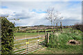
By Highworth Road
The end of a viewpoint pull-in. There are extensive views from here, but not in this direction!
Image: © Robin Webster
Taken: 3 Oct 2014
0.10 miles
3
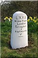
Old Milestone by the B4019, Highworth Road, Faringdon
Carved stone post by the B4019, in parish of GREAT FARINGDON (VALE OF WHITE HORSE District), Highworth Road; opposite Highways Depot, on wide well kept grass verge, near town boundary sign, on North side of road. Highworth Old London Road stone, erected by the Faringdon to Acton Turville (2nd District) turnpike trust in the 18th century.
Inscription reads:-
LXXI
Miles From
London
Faringdon
I
Highworth
V
----
Milestone Society National ID: BE_LBF71
Image: © A Rosevear
Taken: 1 Apr 2006
0.11 miles
4

Bench and Information Board on Highworth Road
The information board is about the limestone and clay landscape.
Image: © Steve Daniels
Taken: 17 Aug 2010
0.12 miles
5
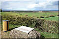
Faded Board at the Viewpoint
The same place as Image eleven years later. There is a small parking area by an overlook where you can stop and admire the view across the upper Thames valley.
The visitor board is looking a bit careworn these days which is a shame because the bits you can read have some interesting information about local geology.
Image: © Des Blenkinsopp
Taken: 6 Apr 2021
0.12 miles
6
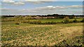
Farmland west of Faringdon
The field in the foreground is being used to grow some as yet unidentified crop. In previous years it has been used for cereals. On the centre right skyline Faringdon Folly can be discerned perched on top of Faringdon Hill. The housing in view is a development from the 1960s or 70s probably.
Image: © Brian Robert Marshall
Taken: 18 Apr 2014
0.15 miles
7
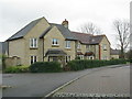
Modern housing on the outskirts of Faringdon
Image: © Sarah Charlesworth
Taken: 28 Jan 2010
0.16 miles

9
View over Faringdon
Looking east from one hill to another with Faringdon in between.
Image: © Des Blenkinsopp
Taken: 6 Apr 2021
0.17 miles
10
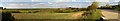
Panoramic view north from the B4019, Faringdon
The authorities have had the wisdom to install a convenient lay-by to enable passing travellers to take in the pleasant views to the north of the B4019, also known as Highworth Road. Visible in the far distance on the full-sized version of this image are buildings at the Royal Air Force base RAF Brize Norton, over 11 kilometres to the north Image
Image: © Brian Robert Marshall
Taken: 18 Apr 2014
0.18 miles