IMAGES TAKEN NEAR TO
Shellingford, FARINGDON, SN7 7PZ
Introduction
This page details the photographs taken nearby to SN7 7PZ by members of the Geograph project.
The Geograph project started in 2005 with the aim of publishing, organising and preserving representative images for every square kilometre of Great Britain, Ireland and the Isle of Man.

There are currently over 7.5m images from over14,400 individuals and you can help contribute to the project by visiting https://www.geograph.org.uk
Image Map
Images are licensed for reuse under creativecommons.org/licenses/by-sa/2.0
Notes
- Clicking on the map will re-center to the selected point.
- The higher the marker number, the further away the image location is from the centre of the postcode.
Image Listing (68 Images Found)
Images are licensed for reuse under creativecommons.org/licenses/by-sa/2.0
Image
Details
Distance
1

Church Street, Shellingford
Looking north.
Image: © Robin Webster
Taken: 18 May 2014
0.01 miles

4
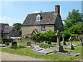
Church Cottage, Shellingford
Church Street runs between the cottage and the cottage on the left.
Image: © Robin Webster
Taken: 18 May 2014
0.02 miles
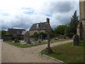
5
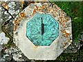
Sundial, Church of St Faith, Church Street, Shellingford
This attractive sundial can be seen in context here Image
Image: © Brian Robert Marshall
Taken: 17 Jul 2012
0.03 miles
6
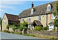
Village house, Shellingford, Oxfordshire
Image: © Oswald Bertram
Taken: 11 Jun 2015
0.03 miles
7
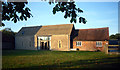
Goodlake Barns, Shellingford
Former farm building converted into cottages for holiday hire. http://www.goodlakebarns.co.uk/
Image: © Des Blenkinsopp
Taken: 21 Sep 2013
0.03 miles
9
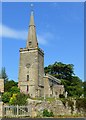
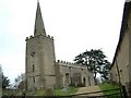
Church of St Faith, Shellingford, Oxfordshire
C12 with porch and spire added c.1625 and late C19 vestry off nave. Coursed and uncoursed limestone rubble, limestone ashlar dressings and spire; metal roof, stone slate roof to porch. Chancel, nave, vestry, south porch and west tower with recessed spire. Early C14 reticulated 3-light east window; late C15 three-light Perpendicular and early C14 one-light window to north chancel wall; south chancel wall has 3 early C14 one-light windows and a fine Norman priests door (possibly reset in early C14) which is of two orders with carved capitals and shaft rings to columns and has dogtooth ornament to arch. North wall of nave has 3 late C15 four-light transomed windows with cusped heads; late C19 vestry has one 2-light C14 style window and steps down to plank door in basement. South wall of nave has one early C14 curvilinear 3-light window and two early C15 eight-light transomed windows to left with cusped heads and human and beasts heads to hood mould terminals. Norman south door of two orders with shaft rings and carved capitals, dog tooth ornament to arch with beasts' head terminal to hood mould; C17 plank double doors. South porch dated 1625 on cartouche above doorway, which has moulded architrave and hood mould to pointed arch and original panelled double doors; one 2-light window with cusped heads; gabled roof with fleur-de-lys finial surmounting coping. Battlements surmounting nave walls are probably early C17. West tower has Norman lancet windows, string course surmounting ground floor corner buttresses and gargoyles at base of battlemented parapet; recessed spire of c.1625 was restored 1852 and has 2-light belfry openings.
(Source:Historic England)
Image: © Oswald Bertram
Taken: 11 Jun 2015
0.03 miles
10
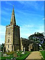
Church of St Faith, Church Street, Shellingford
The rather austere 12th century church is listed Grade I http://www.imagesofengland.org.uk/details/default.aspx?id=251032 The tower was added in the 13th century with the spire being added in 1625. The spire was struck by lightning in 1852 and was rebuilt. However, the pinnacle of the spire subsequently decayed and was replaced with a glass-fibre pinnacle in 1968.
Image: © Brian Robert Marshall
Taken: 17 Jul 2012
0.03 miles