IMAGES TAKEN NEAR TO
Fernham Road, FARINGDON, SN7 7PU
Introduction
This page details the photographs taken nearby to Fernham Road, SN7 7PU by members of the Geograph project.
The Geograph project started in 2005 with the aim of publishing, organising and preserving representative images for every square kilometre of Great Britain, Ireland and the Isle of Man.

There are currently over 7.5m images from over14,400 individuals and you can help contribute to the project by visiting https://www.geograph.org.uk
Image Map
Images are licensed for reuse under creativecommons.org/licenses/by-sa/2.0
Notes
- Clicking on the map will re-center to the selected point.
- The higher the marker number, the further away the image location is from the centre of the postcode.
Image Listing (63 Images Found)
Images are licensed for reuse under creativecommons.org/licenses/by-sa/2.0
Image
Details
Distance


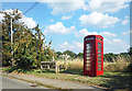
3
K6 telephone box on Fernham Road (B4508), Shellingford
Image: © JThomas
Taken: 15 Jul 2019
0.06 miles
4
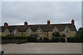
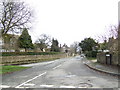
Houses on Fernham Road (B4508), Shellingford
Image: © JThomas
Taken: 15 Jul 2019
0.07 miles
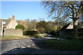
5
Phone Box, Seat & Crab Apple Tree
Beside Fernham Road, Shellingford.
Image: © Des Blenkinsopp
Taken: 11 Aug 2020
0.08 miles
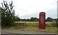
6
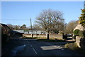
Road junction in Shellingford
No through road meets the B4508
Image: © andrew auger
Taken: 18 Jan 2009
0.10 miles
8
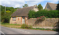
Village Street, Shellingford
This leads to the church and a few houses, finishing in a dead end.
Image: © Jonathan Billinger
Taken: 4 Jan 2007
0.14 miles
9
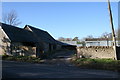
Stone Shed on the Corner
Street access no longer in use. An old workshop or smithy possibly?
Image: © Des Blenkinsopp
Taken: 13 Jun 2020
0.15 miles