IMAGES TAKEN NEAR TO
Fernham, FARINGDON, SN7 7PP
Introduction
This page details the photographs taken nearby to SN7 7PP by members of the Geograph project.
The Geograph project started in 2005 with the aim of publishing, organising and preserving representative images for every square kilometre of Great Britain, Ireland and the Isle of Man.

There are currently over 7.5m images from over14,400 individuals and you can help contribute to the project by visiting https://www.geograph.org.uk
Image Map (Loading...)


Getting Data...Please wait
Leaflet Map data © OpenStreetMap
Images are licensed for reuse under creativecommons.org/licenses/by-sa/2.0
Notes
- Clicking on the map will re-center to the selected point.
- The higher the marker number, the further away the image location is from the centre of the postcode.
Image Listing (8 Images Found)
Images are licensed for reuse under creativecommons.org/licenses/by-sa/2.0
Image
Details
Distance
1
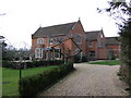
St Mary's Priory
Monastery of the Benedictine Nuns of the Subiaco Congregation.
Image: © Jonathan Billinger
Taken: 4 Jan 2007
0.04 miles
3
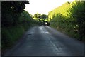
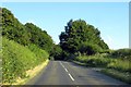
Snowdrops by the roadside
Between Little Coxwell and Fernham.
Image: © Des Blenkinsopp
Taken: 7 Feb 2017
0.11 miles
6
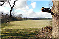
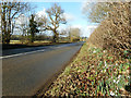
West from Onetree Hill
Undramatic landscape on the ridge of low hills between the Thames and the Vale of White Horse.
Image: © Des Blenkinsopp
Taken: 7 Feb 2017
0.23 miles
7
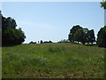
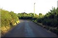
Lower Coxwell Camp hillfort, Onetree Hill
Iron Age hillfort. https://www.megalithic.co.uk/article.php?sid=24257
Image: © Vieve Forward
Taken: 27 Jun 2019
0.24 miles
8
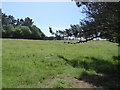
Lower Coxwell Camp hillfort, Onetree Hill
Iron Age hillfort. https://www.megalithic.co.uk/article.php?sid=24257
Image: © Vieve Forward
Taken: 27 Jun 2019
0.24 miles