IMAGES TAKEN NEAR TO
High Street, FARINGDON, SN7 7NY
Introduction
This page details the photographs taken nearby to High Street, SN7 7NY by members of the Geograph project.
The Geograph project started in 2005 with the aim of publishing, organising and preserving representative images for every square kilometre of Great Britain, Ireland and the Isle of Man.

There are currently over 7.5m images from over14,400 individuals and you can help contribute to the project by visiting https://www.geograph.org.uk
Image Map (Loading...)


Getting Data...Please wait
Leaflet Map data © OpenStreetMap
Images are licensed for reuse under creativecommons.org/licenses/by-sa/2.0
Notes
- Clicking on the map will re-center to the selected point.
- The higher the marker number, the further away the image location is from the centre of the postcode.
Image Listing (43 Images Found)
Images are licensed for reuse under creativecommons.org/licenses/by-sa/2.0
Image
Details
Distance
2
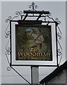
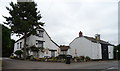
Sign for the Woodman Inn, Fernham
See Image] for context.
Image: © JThomas
Taken: 15 Jul 2019
0.01 miles
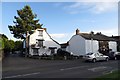
3
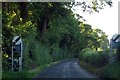
Elmside
The B4508 passes through the left of the picture.
Image: © habiloid
Taken: 29 Jul 2019
0.03 miles
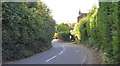
5
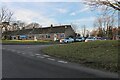
Elmside at the junction of the B4508, Fernham
Image: © David Howard
Taken: 5 Feb 2023
0.03 miles
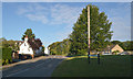
6
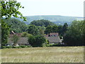
Approaching Fernham, with White Horse Hill in the distance
The Uffington White Horse hill figure can be seen on the hill in the background.
Image: © Vieve Forward
Taken: 27 Jun 2019
0.06 miles