IMAGES TAKEN NEAR TO
Berners Way, FARINGDON, SN7 7NR
Introduction
This page details the photographs taken nearby to Berners Way, SN7 7NR by members of the Geograph project.
The Geograph project started in 2005 with the aim of publishing, organising and preserving representative images for every square kilometre of Great Britain, Ireland and the Isle of Man.

There are currently over 7.5m images from over14,400 individuals and you can help contribute to the project by visiting https://www.geograph.org.uk
Image Map
Images are licensed for reuse under creativecommons.org/licenses/by-sa/2.0
Notes
- Clicking on the map will re-center to the selected point.
- The higher the marker number, the further away the image location is from the centre of the postcode.
Image Listing (23 Images Found)
Images are licensed for reuse under creativecommons.org/licenses/by-sa/2.0
Image
Details
Distance
1
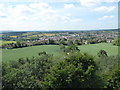
The view from Faringdon Folly 5: SW
With Faringdon in the middle distance, and the line of the Downs on the left horizon.
Image: © Vieve Forward
Taken: 7 Jul 2019
0.12 miles
2
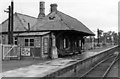
Faringdon station,1950
View SE, towards Uffington: terminus of ex-GWR branch from the main line there, closed to passengers 29/12/51, goods 1/7/63.
Image: © Walter Dendy, deceased
Taken: 24 Sep 1950
0.14 miles
3
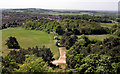
View West from The Folly
Looking westwards from the top of the tower out over Faringdon town with Badbury Hill in the distance.
Image: © Des Blenkinsopp
Taken: 2 May 2011
0.15 miles
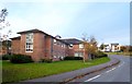
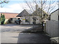
4
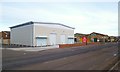
New Units To Let
Recent addition to the area of business premises that were built on the site of the old railway yard.
Image: © Des Blenkinsopp
Taken: 18 Nov 2012
0.18 miles
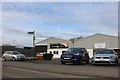
5
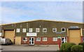
Industrial units on Park Road, Faringdon
Image: © David Howard
Taken: 23 Mar 2019
0.20 miles
6
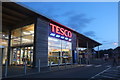
Tesco Metro, Faringdon
Normally a store this size would not be a Metro, which is half way between a Superstore and an Express (which are being closed as they have little business), but as a regular user the names are based on the range of stock rather than the size. Superstores sell electrical goods, books, mobile phones, clothing, toys and have a pharmacy, while normal supermarkets are the same size but only sell standard supermarket stock. The one in Finchley was downgraded using the same building.
Image: © David Howard
Taken: 10 Aug 2019
0.20 miles
7
Industrial units on Park Road, Faringdon
Thanks to my efforts Old Dairy Classics on the right will soon have its own entry on Google Maps
Image: © David Howard
Taken: 23 Mar 2019
0.20 miles
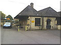
8
Faringdon railway station (site), Oxfordshire
Opened in 1864 by the Faringdon Railway at the end of the short branch from Uffington, this station closed to passengers in 1951 and completely in 1964. The line became part of the Great Western Railway in 1886.
View south east from the boundary and the approximate position of the buffers. The single platform was to the right of the building.
Image: © Nigel Thompson
Taken: 8 Feb 2014
0.20 miles
9
The Old Station Nursery, Park Road
As the name implies, this was Faringdon Station, which was at the end of a branch line from Uffington.
Image: © Roger Templeman
Taken: 9 Oct 2010
0.21 miles