IMAGES TAKEN NEAR TO
Highworth Road, FARINGDON, SN7 7EF
Introduction
This page details the photographs taken nearby to Highworth Road, SN7 7EF by members of the Geograph project.
The Geograph project started in 2005 with the aim of publishing, organising and preserving representative images for every square kilometre of Great Britain, Ireland and the Isle of Man.

There are currently over 7.5m images from over14,400 individuals and you can help contribute to the project by visiting https://www.geograph.org.uk
Image Map (Loading...)


Getting Data...Please wait
Leaflet Map data © OpenStreetMap
Images are licensed for reuse under creativecommons.org/licenses/by-sa/2.0
Notes
- Clicking on the map will re-center to the selected point.
- The higher the marker number, the further away the image location is from the centre of the postcode.
Image Listing (24 Images Found)
Images are licensed for reuse under creativecommons.org/licenses/by-sa/2.0
Image
Details
Distance
1

#4 Highworth Road
There is an OS benchmark Image on the front of the house to the left of the doorway arch
Image: © Roger Templeman
Taken: 18 Oct 2013
0.03 miles
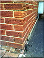
2
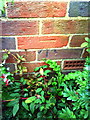
Benchmark on #4 Highworth Road
Ordnance Survey cut mark benchmark described on the Bench Mark Database at http://www.bench-marks.org.uk/bm35703
Image: © Roger Templeman
Taken: 9 Oct 2010
0.03 miles
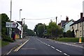
3
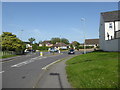
Junction of Highworth Road and Coxwell Road, Faringdon
Image: © Vieve Forward
Taken: 28 Jun 2019
0.05 miles
5
The B4019 meets Coxwell Road in Faringdon
Coxwell Road was the A420 before the building of the Faringdon bypass, which became the A420.
Image: © andrew auger
Taken: 20 Dec 2009
0.05 miles
6
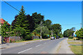
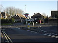
Highworth Road
Highworth Road in Faringdon.
Image: © Wayland Smith
Taken: 10 Jul 2022
0.05 miles
8
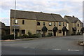
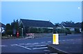
New houses on Fernham Road, Faringdon
These were finished late 2018 or so
Image: © David Howard
Taken: 10 Sep 2019
0.10 miles
9
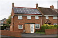
#52 Marlborough Gardens
There is an OS benchmark Image on the side of the house at the front left corner
Image: © Roger Templeman
Taken: 18 Oct 2013
0.14 miles
10
Benchmark on #52 Marlborough Gardens
Ordnance Survey cut mark benchmark described on the Bench Mark Database at http://www.bench-marks.org.uk/bm35702
Image: © Roger Templeman
Taken: 9 Oct 2010
0.18 miles