IMAGES TAKEN NEAR TO
Spinage Close, FARINGDON, SN7 7BW
Introduction
This page details the photographs taken nearby to Spinage Close, SN7 7BW by members of the Geograph project.
The Geograph project started in 2005 with the aim of publishing, organising and preserving representative images for every square kilometre of Great Britain, Ireland and the Isle of Man.

There are currently over 7.5m images from over14,400 individuals and you can help contribute to the project by visiting https://www.geograph.org.uk
Image Map (Loading...)


Getting Data...Please wait
Leaflet Map data © OpenStreetMap
Images are licensed for reuse under creativecommons.org/licenses/by-sa/2.0
Notes
- Clicking on the map will re-center to the selected point.
- The higher the marker number, the further away the image location is from the centre of the postcode.
Image Listing (23 Images Found)
Images are licensed for reuse under creativecommons.org/licenses/by-sa/2.0
Image
Details
Distance
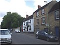
1
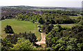
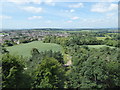
The view from Faringdon Folly 5: SW
With Faringdon in the middle distance, and the line of the Downs on the left horizon.
Image: © Vieve Forward
Taken: 7 Jul 2019
0.02 miles
2
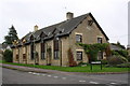
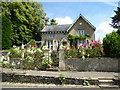
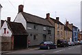
Former National School at Stanford Road/Berners Way junction
Now a private residence, the building, now called 'The Bell House', retains the old school bell above a date stone which is inscribed 'National School 1823'. There is an OS benchmark Image on the near corner on the Stanford Road face behind the creeper
Image: © Roger Templeman
Taken: 18 Oct 2013
0.14 miles
3
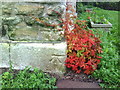
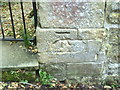
Benchmark on former National School, Stanford Road
Ordnance Survey cut mark benchmark described on the Bench Mark Database at http://www.bench-marks.org.uk/bm35706
Image: © Roger Templeman
Taken: 9 Oct 2010
0.14 miles
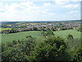
4
View West from The Folly
Looking westwards from the top of the tower out over Faringdon town with Badbury Hill in the distance.
Image: © Des Blenkinsopp
Taken: 2 May 2011
0.15 miles
6
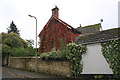
#1 Kiln Cottages, Stanford Road
There is an OS benchmark Image on the right hand side gatepost at the gateway at the left hand edge of the image
Image: © Roger Templeman
Taken: 18 Oct 2013
0.19 miles
7
Benchmark on gatepost of #1 Kiln Cottages, Stanford Road
Ordnance Survey cut mark benchmark described on the Bench Mark Database at http://www.bench-marks.org.uk/bm35707
Image: © Roger Templeman
Taken: 9 Oct 2010
0.19 miles
8
The view from Faringdon Folly 4: West
With Faringdon in the middle distance, Badbury Hill on the horizon, and people walking up the path to the Folly in the foreground.
Image: © Vieve Forward
Taken: 7 Jul 2019
0.21 miles
9
The Folly on London Street
The Folly is a former Morrells public house.
Image: © Steve Daniels
Taken: 14 Apr 2013
0.21 miles