IMAGES TAKEN NEAR TO
Cadels Row, FARINGDON, SN7 7AX
Introduction
This page details the photographs taken nearby to Cadels Row, SN7 7AX by members of the Geograph project.
The Geograph project started in 2005 with the aim of publishing, organising and preserving representative images for every square kilometre of Great Britain, Ireland and the Isle of Man.

There are currently over 7.5m images from over14,400 individuals and you can help contribute to the project by visiting https://www.geograph.org.uk
Image Map (Loading...)


Getting Data...Please wait
Leaflet Map data © OpenStreetMap
Images are licensed for reuse under creativecommons.org/licenses/by-sa/2.0
Notes
- Clicking on the map will re-center to the selected point.
- The higher the marker number, the further away the image location is from the centre of the postcode.
Image Listing (98 Images Found)
Images are licensed for reuse under creativecommons.org/licenses/by-sa/2.0
Image
Details
Distance
1
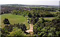
View West from The Folly
Looking westwards from the top of the tower out over Faringdon town with Badbury Hill in the distance.
Image: © Des Blenkinsopp
Taken: 2 May 2011
0.07 miles
2
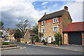
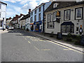
Three storeyed brick and stone house - Faringdon
Image: © Mick Lobb
Taken: 12 May 2010
0.13 miles
4
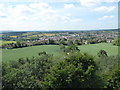
The view from Faringdon Folly 5: SW
With Faringdon in the middle distance, and the line of the Downs on the left horizon.
Image: © Vieve Forward
Taken: 7 Jul 2019
0.15 miles
5
Looking up London Street from the Market Place, Faringdon
Image: © Chris Gunns
Taken: 4 Sep 2009
0.15 miles
6
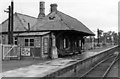
Faringdon station,1950
View SE, towards Uffington: terminus of ex-GWR branch from the main line there, closed to passengers 29/12/51, goods 1/7/63.
Image: © Walter Dendy, deceased
Taken: 24 Sep 1950
0.16 miles
8
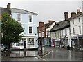
Faringdon - Market Place
View from the Old Town Hall towards London Street, one of several shopping streets leading to/from the Market Place, Faringdon's historic hub.
www.faringdontowncouncil.gov.uk
Image: © Colin Smith
Taken: 5 Aug 2023
0.16 miles
9
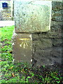
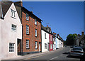
Benchmark on the Baptist Church, Bromsgrove
Ordnance Survey cut mark benchmark described on the Bench Mark Database at http://www.bench-marks.org.uk/bm35704
Image: © Roger Templeman
Taken: 9 Oct 2010
0.16 miles
10
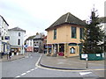
Market House, Faringdon
Complete with Christmas tree on the tenth day of Christmas.
Image: © Jonathan Billinger
Taken: 4 Jan 2007
0.16 miles