IMAGES TAKEN NEAR TO
Goodlake Avenue, FARINGDON, SN7 7AP
Introduction
This page details the photographs taken nearby to Goodlake Avenue, SN7 7AP by members of the Geograph project.
The Geograph project started in 2005 with the aim of publishing, organising and preserving representative images for every square kilometre of Great Britain, Ireland and the Isle of Man.

There are currently over 7.5m images from over14,400 individuals and you can help contribute to the project by visiting https://www.geograph.org.uk
Image Map (Loading...)


Getting Data...Please wait
Leaflet Map data © OpenStreetMap
Images are licensed for reuse under creativecommons.org/licenses/by-sa/2.0
Notes
- Clicking on the map will re-center to the selected point.
- The higher the marker number, the further away the image location is from the centre of the postcode.
Image Listing (95 Images Found)
Images are licensed for reuse under creativecommons.org/licenses/by-sa/2.0
Image
Details
Distance
1
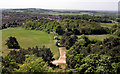
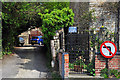
View West from The Folly
Looking westwards from the top of the tower out over Faringdon town with Badbury Hill in the distance.
Image: © Des Blenkinsopp
Taken: 2 May 2011
0.02 miles
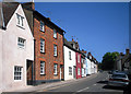
3
Three storeyed brick and stone house - Faringdon
Image: © Mick Lobb
Taken: 12 May 2010
0.12 miles
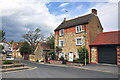
6
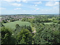
The view from Faringdon Folly 4: West
With Faringdon in the middle distance, Badbury Hill on the horizon, and people walking up the path to the Folly in the foreground.
Image: © Vieve Forward
Taken: 7 Jul 2019
0.13 miles
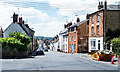
7
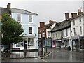
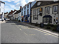
Faringdon - Market Place
View from the Old Town Hall towards London Street, one of several shopping streets leading to/from the Market Place, Faringdon's historic hub.
www.faringdontowncouncil.gov.uk
Image: © Colin Smith
Taken: 5 Aug 2023
0.14 miles
8
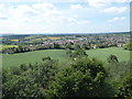
The view from Faringdon Folly 5: SW
With Faringdon in the middle distance, and the line of the Downs on the left horizon.
Image: © Vieve Forward
Taken: 7 Jul 2019
0.14 miles
9
Looking up London Street from the Market Place, Faringdon
Image: © Chris Gunns
Taken: 4 Sep 2009
0.14 miles
10
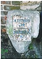
Old Milestone by London Street, Faringdon
Metal plate attached to stone post by the UC road (was A420), in parish of GREAT FARINGDON (VALE OF WHITE HORSE District), London Street; 30m South of Stanford Road, by The Folly Inn PH, in pavement, against the wall of the buildings, on South side of road. Faringdon post and iron plate, erected by the Fyfield, Newbridge & St John's Bridge turnpike trust in the 19th century.
Inscription reads:-
ABINGD
14
-----
LECHLAE
6
Milestone Society National ID: BE_LG70.
Image: © A Rosevear
Taken: 16 Sep 2001
0.14 miles