IMAGES TAKEN NEAR TO
Watchfield, SWINDON, SN6 8TH
Introduction
This page details the photographs taken nearby to SN6 8TH by members of the Geograph project.
The Geograph project started in 2005 with the aim of publishing, organising and preserving representative images for every square kilometre of Great Britain, Ireland and the Isle of Man.

There are currently over 7.5m images from over14,400 individuals and you can help contribute to the project by visiting https://www.geograph.org.uk
Image Map
Images are licensed for reuse under creativecommons.org/licenses/by-sa/2.0
Notes
- Clicking on the map will re-center to the selected point.
- The higher the marker number, the further away the image location is from the centre of the postcode.
Image Listing (11 Images Found)
Images are licensed for reuse under creativecommons.org/licenses/by-sa/2.0
Image
Details
Distance
1
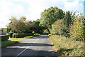
The B4508
Looking west from outside West Mill Farm.
Image: © andrew auger
Taken: 10 Oct 2009
0.03 miles
2
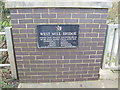
West Mill Bridge
Supplemental at the position of the picture in Image The plaque says it all!
Image: © Jonathan Billinger
Taken: 4 Jan 2007
0.04 miles
5
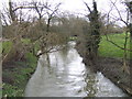
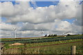
River Cole looking south-west
The river here is also the county boundary; Oxfordshire on the left, Wiltshire on the right.
Image: © Jonathan Billinger
Taken: 4 Jan 2007
0.10 miles
7
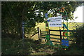
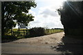
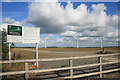
Footpaths to Shrivenham and Watchfield
Both 2 miles. Also a close up of the advertising sign seen in SU2390 Entrance to West Mill Farm.
Image: © andrew auger
Taken: 10 Oct 2009
0.12 miles
9
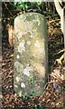
Old Milestone by the B4508, west of Watchfield
Carved stone post by the B4508, in parish of Watchfield (Vale of White Horse District), hill above Westmill Farm, on wide verge under overgrown bushes, downhill of lane to Watchfield Common, on North side of road. Shrivenham Old London Road, erected by the Faringdon to Acton Turville (2nd District) turnpike trust in the 18th century.
Inscription reads:-
LXXV
Miles from
London
Carved benchmark bottom front.
Milestone Society National ID: BE_LBS75
Image: © A Rosevear
Taken: 27 Oct 2001
0.18 miles
10
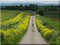
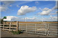
Farm road, Watchfield
The drive to Strattenborough Castle Farm is lined with a wild mustard-type plant, which has been identified as warty-cabbage (Bunias orientalis) by Mick Crawley. It has an unpleasant fragrance. The mast on Fox Hill can be seen on the downs. The land to the right is in small scale vegetable production. To the left is a crop of barley.
Image: © Andrew Smith
Taken: 24 May 2007
0.23 miles