IMAGES TAKEN NEAR TO
High Street, SWINDON, SN6 8SW
Introduction
This page details the photographs taken nearby to High Street, SN6 8SW by members of the Geograph project.
The Geograph project started in 2005 with the aim of publishing, organising and preserving representative images for every square kilometre of Great Britain, Ireland and the Isle of Man.

There are currently over 7.5m images from over14,400 individuals and you can help contribute to the project by visiting https://www.geograph.org.uk
Image Map
Images are licensed for reuse under creativecommons.org/licenses/by-sa/2.0
Notes
- Clicking on the map will re-center to the selected point.
- The higher the marker number, the further away the image location is from the centre of the postcode.
Image Listing (51 Images Found)
Images are licensed for reuse under creativecommons.org/licenses/by-sa/2.0
Image
Details
Distance
1
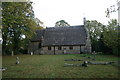
St Thomas, Watchfield: early August 2020
Image: © Basher Eyre
Taken: 5 Aug 2020
0.00 miles
3
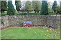
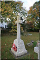
Garden of remembrance sign
In Watchfield churchyard.
Image: © andrew auger
Taken: 10 Oct 2009
0.01 miles
8
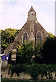
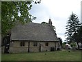
St Thomas, Watchfield
Grade 2 listed building erected in 1857.
Image: © Michael FORD
Taken: Unknown
0.02 miles
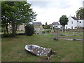
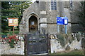
10
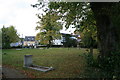
St. Thomas, Watchfield churchyard (2)
Image: © andrew auger
Taken: 10 Oct 2009
0.02 miles