IMAGES TAKEN NEAR TO
Meadow Road, SWINDON, SN6 8SF
Introduction
This page details the photographs taken nearby to Meadow Road, SN6 8SF by members of the Geograph project.
The Geograph project started in 2005 with the aim of publishing, organising and preserving representative images for every square kilometre of Great Britain, Ireland and the Isle of Man.

There are currently over 7.5m images from over14,400 individuals and you can help contribute to the project by visiting https://www.geograph.org.uk
Image Map (Loading...)


Getting Data...Please wait
Leaflet Map data © OpenStreetMap
Images are licensed for reuse under creativecommons.org/licenses/by-sa/2.0
Notes
- Clicking on the map will re-center to the selected point.
- The higher the marker number, the further away the image location is from the centre of the postcode.
Image Listing (25 Images Found)
Images are licensed for reuse under creativecommons.org/licenses/by-sa/2.0
Image
Details
Distance
1
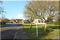
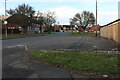
Folly Crescent, Watchfield
The sign is for a cycle train route to do with a school off to the right.
Image: © Des Blenkinsopp
Taken: 7 Feb 2017
0.08 miles
2
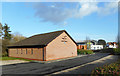
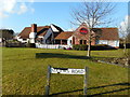
Jehovah's Witnesses' Hall, Watchfield
Image: © Des Blenkinsopp
Taken: 7 Feb 2017
0.08 miles
4
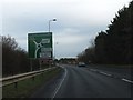
A420 approaching Watchfield Roundabout
There is a slip-road signed for through traffic on the A420.
Image: © David Smith
Taken: 28 Dec 2011
0.11 miles

7

College Farm, Majors Road, Watchfield, Oxon
College Farm is a large food orientated public house which was opened by Marston's a few years ago. It does have a wide range of drinks, including real ale. It is conveniently located just off the A420 Swindon to Oxford road. Marston's are one of the few major pub groups who are still opening new build pubs; all of them food orientated.
Image: © P L Chadwick
Taken: 19 Nov 2018
0.14 miles
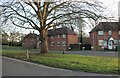
8
Pub and Pizza, Watchfield
Near to a sizeable residential area but also a handy stop just off the busy A420 this pizza place with The College Farm pub on the left caters for locals and drivers alike.
Image: © Des Blenkinsopp
Taken: 7 Feb 2017
0.14 miles
9
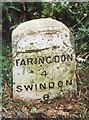
Old Milestone by the former A420, Faringdon Road
Carved stone post by the UC road (was A420), in parish of Watchfield (Vale of White Horse District), Faringdon Road; just West of roundabout to Royal Military College of Science, in ditch behind wide grass verge, on North side of road. Faringdon tombstone, erected by the Faringdon to Acton Turville (2nd District) turnpike trust in the 19th century.
Inscription reads:-
FARINGDON
4
SWINDON
8
Oxfordshire HER.
HER Number: 10125 https://www.heritagegateway.org.uk/Gateway/Results_Single.aspx?uid=MOX10181&resourceID=1033
Milestone Society National ID: BE_FASN04
Image: © A Rosevear
Taken: 23 Sep 2001
0.14 miles
10
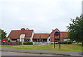
The College Farm, Watchfield
On Majors Road.
Image: © JThomas
Taken: 15 Jul 2019
0.14 miles