IMAGES TAKEN NEAR TO
Mount Pleasant, SWINDON, SN6 8PN
Introduction
This page details the photographs taken nearby to Mount Pleasant, SN6 8PN by members of the Geograph project.
The Geograph project started in 2005 with the aim of publishing, organising and preserving representative images for every square kilometre of Great Britain, Ireland and the Isle of Man.

There are currently over 7.5m images from over14,400 individuals and you can help contribute to the project by visiting https://www.geograph.org.uk
Image Map (Loading...)


Getting Data...Please wait
Leaflet Map data © OpenStreetMap
Images are licensed for reuse under creativecommons.org/licenses/by-sa/2.0
Notes
- Clicking on the map will re-center to the selected point.
- The higher the marker number, the further away the image location is from the centre of the postcode.
Image Listing (74 Images Found)
Images are licensed for reuse under creativecommons.org/licenses/by-sa/2.0
Image
Details
Distance
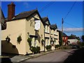
1
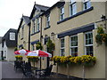
The True Heart
Village inn on Bishopstone's High Street - closed in the afternoons!
Image: © Colin Smith
Taken: 23 May 2008
0.04 miles
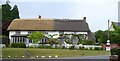
4
True Heart pub, Bishopstone, Swindon
This is one of two public houses in the village. This one is a free house.
Image: © Brian Robert Marshall
Taken: 6 Mar 2007
0.05 miles
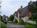
5
Titchener's Cottage, High Street
Thatched cottage built of chalk blocks and brick.
Image: © Vieve Forward
Taken: 24 Dec 2018
0.06 miles
6
Bishopstone
Thatched cottages on the main road running through the spring line village below the Ridgeway.
Image: © Colin Smith
Taken: 23 May 2008
0.07 miles
7
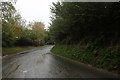
High Street, Bishopstone
Quiet lane in the middle of the "white village" which has many cottages built of chalk blocks.
Image: © Colin Smith
Taken: 23 May 2008
0.07 miles
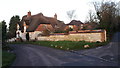
8
Bishopstone School
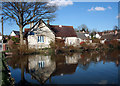
Another image of this very attractive village pond, this time featuring the primary school which is still operating in its original building.
Image: © Des Blenkinsopp
Taken: 8 Apr 2010
0.07 miles
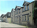
9
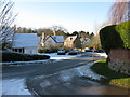
Bishopstone village hall on Hocker Bench
One map shows the road as Hocker Bench, Google maps as Rocker Bench.
Image: © Nick Smith
Taken: 3 Jan 2010
0.07 miles