IMAGES TAKEN NEAR TO
Kingstone Winslow, SWINDON, SN6 8NH
Introduction
This page details the photographs taken nearby to SN6 8NH by members of the Geograph project.
The Geograph project started in 2005 with the aim of publishing, organising and preserving representative images for every square kilometre of Great Britain, Ireland and the Isle of Man.

There are currently over 7.5m images from over14,400 individuals and you can help contribute to the project by visiting https://www.geograph.org.uk
Image Map
Images are licensed for reuse under creativecommons.org/licenses/by-sa/2.0
Notes
- Clicking on the map will re-center to the selected point.
- The higher the marker number, the further away the image location is from the centre of the postcode.
Image Listing (16 Images Found)
Images are licensed for reuse under creativecommons.org/licenses/by-sa/2.0
Image
Details
Distance
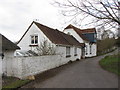
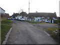
1
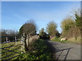
Country lane, Kingstone Winslow
A public footpath leaves the lane on the right.
Image: © Vieve Forward
Taken: 9 Jan 2019
0.02 miles
2
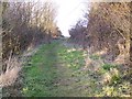
Footpath, Kingstone Winslow
Footpath to Odstone Farm.
Image: © Maigheach-gheal
Taken: 30 Jan 2010
0.07 miles
3
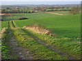
Farmland, Ashbury
A track and arable land on the hillside beside the hamlet of Kingstone Winslow. Beyond is the flat expanse of the Vale of Whitehorse.
Image: © Andrew Smith
Taken: 29 Dec 2007
0.09 miles
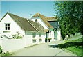
4
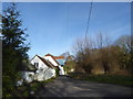
Upper Mill, Kingstone Winslow
The Upper Mill dates from 1792 according to a carved stone in its wall.
Image: © Vieve Forward
Taken: 9 Jan 2019
0.09 miles
6
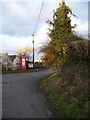
Telephone box, Kingstone Winslow
A K6 type telephone box in a more residential area of the village.
Image: © Maigheach-gheal
Taken: 30 Jan 2010
0.10 miles
7
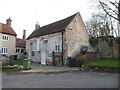
Kingstone Lower Mill, Station Road, Kingstone Winslow
Grade II listed watermill with water wheel.
Image: © Vieve Forward
Taken: 9 Jan 2019
0.11 miles
8
Upper Mill, Kingstone Winslow / Ashbury, Oxfordshire
The Upper Mill can be found as a model in the renowned Pendon Museum, a historic and highly accurate portrayal in miniature of the rural Vale of the White Horse in the thirties. http://www.pendonmuseum.com A picture of the model mill can be seen at http://www.abingdon.angle.uk.com/attractions/pendon.html The model scene shows elm trees in abundance, sadly a feature no more. The modern day mill pond (just off to the right in the photograph) is now surrounded by willow trees.
Image: © Alan Cooper
Taken: 3 Jun 2006
0.12 miles
10
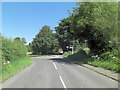
B4000 (Station Road) junction with minor road
Image: © Stuart Logan
Taken: 24 Jul 2012
0.17 miles