IMAGES TAKEN NEAR TO
Stainswick Lane, SWINDON, SN6 8LD
Introduction
This page details the photographs taken nearby to Stainswick Lane, SN6 8LD by members of the Geograph project.
The Geograph project started in 2005 with the aim of publishing, organising and preserving representative images for every square kilometre of Great Britain, Ireland and the Isle of Man.

There are currently over 7.5m images from over14,400 individuals and you can help contribute to the project by visiting https://www.geograph.org.uk
Image Map (Loading...)


Getting Data...Please wait
Leaflet Map data © OpenStreetMap
Images are licensed for reuse under creativecommons.org/licenses/by-sa/2.0
Notes
- Clicking on the map will re-center to the selected point.
- The higher the marker number, the further away the image location is from the centre of the postcode.
Image Listing (7 Images Found)
Images are licensed for reuse under creativecommons.org/licenses/by-sa/2.0
Image
Details
Distance
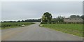
3
B4000 passes entrance to Stainswick Farm
Image: © Stuart Logan
Taken: 24 Jul 2012
0.08 miles

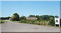
5

Farmland, Ashbury
A tree in oil-seed rape to the west of the B4000.
Image: © Andrew Smith
Taken: 16 Apr 2011
0.15 miles
6
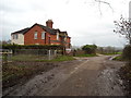
Cottages, Stainswick Lane
Red brick cottages next to a muddy Stainswick Lane.
Image: © Vieve Forward
Taken: 26 Dec 2015
0.19 miles
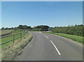
7
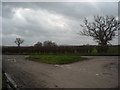
Junction of Stainswick Lane and the B 4000
The escarpment of the Downs in the vicinity of Charlbury Hill and Fox Hill can be seen in the distance.
Image: © Vieve Forward
Taken: 26 Dec 2015
0.20 miles