IMAGES TAKEN NEAR TO
Beckett Avenue, SWINDON, SN6 8HA
Introduction
This page details the photographs taken nearby to Beckett Avenue, SN6 8HA by members of the Geograph project.
The Geograph project started in 2005 with the aim of publishing, organising and preserving representative images for every square kilometre of Great Britain, Ireland and the Isle of Man.

There are currently over 7.5m images from over14,400 individuals and you can help contribute to the project by visiting https://www.geograph.org.uk
Image Map (Loading...)


Getting Data...Please wait
Leaflet Map data © OpenStreetMap
Images are licensed for reuse under creativecommons.org/licenses/by-sa/2.0
Notes
- Clicking on the map will re-center to the selected point.
- The higher the marker number, the further away the image location is from the centre of the postcode.
Image Listing (26 Images Found)
Images are licensed for reuse under creativecommons.org/licenses/by-sa/2.0
Image
Details
Distance
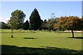
2
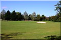
A bunker on Shrivenham Park Golf Course
Image: © Steve Daniels
Taken: 21 Aug 2011
0.14 miles
3
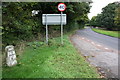
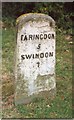
Faringdon Road from entrance to Shrivenham Park Golf Club
In the verge the Faringdon 5 Swindon 7 milestone
Image: © Roger Templeman
Taken: 18 Oct 2013
0.14 miles
4
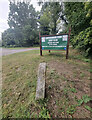
Old Milestone by the former A420 in Shrivenham
Carved stone post by the UC road (was A420), in parish of Shrivenham (Vale of White Horse District), Faringdon Road; Shrivenham Golf Club entrance, on wide well kept grass verge, beside Club signs, on North side of road. Faringdon tombstone, erected by the Faringdon to Acton Turville (2nd District) turnpike trust in the 19th century.
Inscription reads:-
FARINGDON
5
SWINDON
7
Oxfordshire HER.
HER Number: 10126 https://www.heritagegateway.org.uk/Gateway/Results_Single.aspx?uid=MOX9446&resourceID=1033
Milestone Society National ID: BE_FASN05
Image: © Kirsty Hackett
Taken: 26 Aug 2024
0.17 miles
5
Old Milestone by the former A420 in Shrivenham
Carved stone post by the UC road (was A420), in parish of Shrivenham (Vale of White Horse District), Faringdon Road; Shrivenham Golf Club entrance, on wide well kept grass verge, beside Club signs, on North side of road. Faringdon tombstone, erected by the Faringdon to Acton Turville (2nd District) turnpike trust in the 19th century.
Inscription reads:-
FARINGDON
5
SWINDON
7
Oxfordshire HER.
HER Number: 10126 https://www.heritagegateway.org.uk/Gateway/Results_Single.aspx?uid=MOX9446&resourceID=1033
Milestone Society National ID: BE_FASN05
Image: © A Rosevear
Taken: 23 Sep 2001
0.17 miles
8
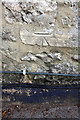
Benchmark on Tarifa Cottage
Ordnance Survey cut mark benchmark described on the Bench Mark Database at http://www.bench-marks.org.uk/bm35774
Image: © Roger Templeman
Taken: 18 Oct 2013
0.18 miles
9
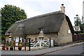
Tarifa Cottage, #14 Faringdon Road
There is an OS benchmark Image above the pavement below the white notice which reads:
"By order of the Magistrates,
All idle or disorderly persons
found and apprehended in the
Parish of Shrivenham, will be
dealt with as the Law directs.
Shrivenham Parish
Overseers"
Image: © Roger Templeman
Taken: 18 Oct 2013
0.18 miles
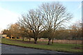
10
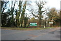
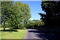
The entrance to Shrivenham Park Golf Club
Image: © David Howard
Taken: 5 Feb 2023
0.18 miles