IMAGES TAKEN NEAR TO
Ballingers, SWINDON, SN6 8FP
Introduction
This page details the photographs taken nearby to Ballingers, SN6 8FP by members of the Geograph project.
The Geograph project started in 2005 with the aim of publishing, organising and preserving representative images for every square kilometre of Great Britain, Ireland and the Isle of Man.

There are currently over 7.5m images from over14,400 individuals and you can help contribute to the project by visiting https://www.geograph.org.uk
Image Map
Images are licensed for reuse under creativecommons.org/licenses/by-sa/2.0
Notes
- Clicking on the map will re-center to the selected point.
- The higher the marker number, the further away the image location is from the centre of the postcode.
Image Listing (52 Images Found)
Images are licensed for reuse under creativecommons.org/licenses/by-sa/2.0
Image
Details
Distance
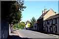
3
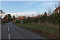
Stainswick Lane, Shrivenham
Junction with Stonefield Close.
Image: © Des Blenkinsopp
Taken: 7 Feb 2017
0.15 miles
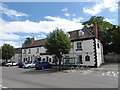
4
Giotto
Italian restaurant in an old building on the southern side of Shrivenham High Street.
http://www.shrivenham.org/
Image: © Colin Smith
Taken: 21 May 2008
0.16 miles
5

Footpath near Shrivenham
Footpath near Shrivenham.
Image: © Wayland Smith
Taken: 23 Apr 2021
0.16 miles
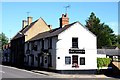
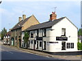
7
Barrington Arms Hotel, Shrivenham: early August 2020
Image: © Basher Eyre
Taken: 5 Aug 2020
0.16 miles
9
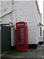
Telephone box, Shrivenham
A K6 type telephone box on the High Street.
Image: © Maigheach-gheal
Taken: 30 Jan 2010
0.18 miles
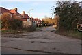
10
Entrance to cemetery from Stainswick Lane
Image: © Roger Templeman
Taken: 18 Oct 2013
0.18 miles