IMAGES TAKEN NEAR TO
Cowleaze Close, SWINDON, SN6 8EH
Introduction
This page details the photographs taken nearby to Cowleaze Close, SN6 8EH by members of the Geograph project.
The Geograph project started in 2005 with the aim of publishing, organising and preserving representative images for every square kilometre of Great Britain, Ireland and the Isle of Man.

There are currently over 7.5m images from over14,400 individuals and you can help contribute to the project by visiting https://www.geograph.org.uk
Image Map
Images are licensed for reuse under creativecommons.org/licenses/by-sa/2.0
Notes
- Clicking on the map will re-center to the selected point.
- The higher the marker number, the further away the image location is from the centre of the postcode.
Image Listing (24 Images Found)
Images are licensed for reuse under creativecommons.org/licenses/by-sa/2.0
Image
Details
Distance
1
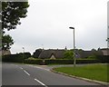
Fairthorne Way
Fairthorne Way passing Sandy Lane
Image: © Shaun Ferguson
Taken: 17 Dec 2010
0.08 miles
2
Berens Road, Shrivenham
A housing estate road
Image: © David Smith
Taken: 9 Jun 2018
0.14 miles
3
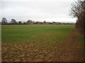
Arable field west of Station Road, Shrivenham
Across the field from the footpath, a barn can be seen adjacent to Station Road in the distance.
Image: © Vieve Forward
Taken: 9 Mar 2015
0.15 miles
5
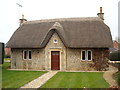
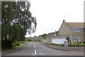
West End, Station Road, Shrivenham
Thatched cottage, possibly a former school.
Image: © Vieve Forward
Taken: 9 Mar 2015
0.19 miles
6
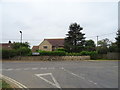
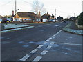
Road junction on Highworth Road (B4000), Shrivenham
Image: © JThomas
Taken: 15 Jul 2019
0.20 miles
7
Stainswick Lane, Shrivenham
Junction with Stonefield Close.
Image: © Des Blenkinsopp
Taken: 7 Feb 2017
0.20 miles
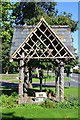
9
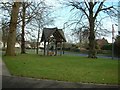
Shrivenham Pump
The old village water pump
Image: © Colin Bates
Taken: 24 Dec 2005
0.21 miles
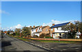
10
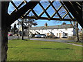
Terrace on Townsend Road
Viewed from the shelter over the old pump on the green. As the street name suggests, this was the edge of the village before post war expansion to the west.
Image: © Des Blenkinsopp
Taken: 7 Feb 2017
0.21 miles