IMAGES TAKEN NEAR TO
Charlbury Road, SWINDON, SN6 8EE
Introduction
This page details the photographs taken nearby to Charlbury Road, SN6 8EE by members of the Geograph project.
The Geograph project started in 2005 with the aim of publishing, organising and preserving representative images for every square kilometre of Great Britain, Ireland and the Isle of Man.

There are currently over 7.5m images from over14,400 individuals and you can help contribute to the project by visiting https://www.geograph.org.uk
Image Map (Loading...)


Getting Data...Please wait
Leaflet Map data © OpenStreetMap
Images are licensed for reuse under creativecommons.org/licenses/by-sa/2.0
Notes
- Clicking on the map will re-center to the selected point.
- The higher the marker number, the further away the image location is from the centre of the postcode.
Image Listing (27 Images Found)
Images are licensed for reuse under creativecommons.org/licenses/by-sa/2.0
Image
Details
Distance
1
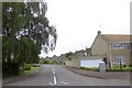
Berens Road, Shrivenham
A housing estate road
Image: © David Smith
Taken: 9 Jun 2018
0.06 miles
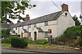
3
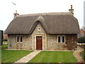
West End, Station Road, Shrivenham
Thatched cottage, possibly a former school.
Image: © Vieve Forward
Taken: 9 Mar 2015
0.10 miles
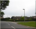
4
Fairthorne Way
Fairthorne Way passing Sandy Lane
Image: © Shaun Ferguson
Taken: 17 Dec 2010
0.14 miles
5
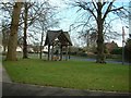
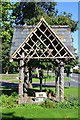
Shrivenham Pump
The old village water pump
Image: © Colin Bates
Taken: 24 Dec 2005
0.14 miles
6
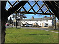
Terrace on Townsend Road
Viewed from the shelter over the old pump on the green. As the street name suggests, this was the edge of the village before post war expansion to the west.
Image: © Des Blenkinsopp
Taken: 7 Feb 2017
0.14 miles
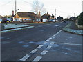
7
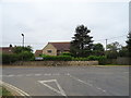
Road junction on Highworth Road (B4000), Shrivenham
Image: © JThomas
Taken: 15 Jul 2019
0.14 miles
9
Houses on Townsend
There is an OS benchmark Image on the front face of the near side of the porch on the nearest house
Image: © Roger Templeman
Taken: 18 Oct 2013
0.15 miles
10

Benchmark on #2 Townsend Road
Ordnance Survey cut mark benchmark described on the Bench Mark Database at http://www.bench-marks.org.uk/bm51716
Image: © Roger Templeman
Taken: 18 Oct 2013
0.15 miles