IMAGES TAKEN NEAR TO
Lushill, SWINDON, SN6 7TD
Introduction
This page details the photographs taken nearby to Lushill, SN6 7TD by members of the Geograph project.
The Geograph project started in 2005 with the aim of publishing, organising and preserving representative images for every square kilometre of Great Britain, Ireland and the Isle of Man.

There are currently over 7.5m images from over14,400 individuals and you can help contribute to the project by visiting https://www.geograph.org.uk
Image Map (Loading...)


Getting Data...Please wait
Leaflet Map data © OpenStreetMap
Images are licensed for reuse under creativecommons.org/licenses/by-sa/2.0
Notes
- Clicking on the map will re-center to the selected point.
- The higher the marker number, the further away the image location is from the centre of the postcode.
Image Listing (4 Images Found)
Images are licensed for reuse under creativecommons.org/licenses/by-sa/2.0
Image
Details
Distance
1
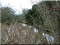
Share Ditch, Lushill, Swindon
An upstream view. The Share Ditch connects with the Wiltshire side of the Thames about 2 kms to the north-east.
Image: © Brian Robert Marshall
Taken: 1 Jan 2007
0.09 miles
2

Share Ditch, Lushill, Swindon
Looking downstream.
Image: © Brian Robert Marshall
Taken: 1 Jan 2007
0.10 miles
3
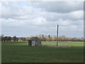
Pump house
This small wooden building has an electric pump for water extraction purposes.
Image: © Jonathan Billinger
Taken: 7 Mar 2007
0.16 miles