IMAGES TAKEN NEAR TO
Swindon Road, SWINDON, SN6 7SL
Introduction
This page details the photographs taken nearby to Swindon Road, SN6 7SL by members of the Geograph project.
The Geograph project started in 2005 with the aim of publishing, organising and preserving representative images for every square kilometre of Great Britain, Ireland and the Isle of Man.

There are currently over 7.5m images from over14,400 individuals and you can help contribute to the project by visiting https://www.geograph.org.uk
Image Map
Images are licensed for reuse under creativecommons.org/licenses/by-sa/2.0
Notes
- Clicking on the map will re-center to the selected point.
- The higher the marker number, the further away the image location is from the centre of the postcode.
Image Listing (4 Images Found)
Images are licensed for reuse under creativecommons.org/licenses/by-sa/2.0
Image
Details
Distance
1
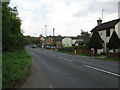
Houses along the A361 at Redlands, just before Highworth
Image: © Nick Smith
Taken: 24 Sep 2011
0.01 miles
2
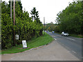
View along the A361 Swindon Road towards Highworth
Image: © Nick Smith
Taken: 24 Sep 2011
0.18 miles
3
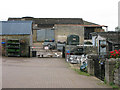
Entrance and buildings of Red Down Farm shop and tea rooms
Image: © Nick Smith
Taken: 24 Sep 2011
0.24 miles
4
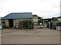
Red Down farm shop and tea rooms
Not much has changed in four and a half years Image
Image: © Nick Smith
Taken: 24 Sep 2011
0.25 miles