IMAGES TAKEN NEAR TO
Hampton, SWINDON, SN6 7RL
Introduction
This page details the photographs taken nearby to Hampton, SN6 7RL by members of the Geograph project.
The Geograph project started in 2005 with the aim of publishing, organising and preserving representative images for every square kilometre of Great Britain, Ireland and the Isle of Man.

There are currently over 7.5m images from over14,400 individuals and you can help contribute to the project by visiting https://www.geograph.org.uk
Image Map
Images are licensed for reuse under creativecommons.org/licenses/by-sa/2.0
Notes
- Clicking on the map will re-center to the selected point.
- The higher the marker number, the further away the image location is from the centre of the postcode.
Image Listing (12 Images Found)
Images are licensed for reuse under creativecommons.org/licenses/by-sa/2.0
Image
Details
Distance
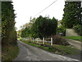
2

The hamlet of Hampton, Highworth near Swindon
A compact little settlement off the main road from Highworth to Blunsdon.
Image: © Brian Robert Marshall
Taken: 1 Jan 2007
0.04 miles
3
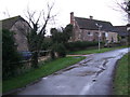
The Old Farmhouse, Hampton
Grade II Listed farmhouse probably originally 16th century. http://www.britishlistedbuildings.co.uk/en-318383-the-old-farmhouse-highworth- Notice the buttresses, one on the corner and two flanking the front door.
Image: © Vieve Forward
Taken: 29 Jan 2013
0.05 miles
5

Stile, north of Hampton
The lower part of the stile is stone. This is the first one like this I've seen locally. The footpath isn't very well defined but leads away from the stile to Highworth Cemetery on the other side of the hill.
Image: © Brian Robert Marshall
Taken: 22 Jan 2009
0.12 miles
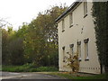
6

Field north of Hampton
In this view to the east north east the western edge of the small town of Highworth can just be seen near the horizon.
Image: © Brian Robert Marshall
Taken: 22 Jan 2009
0.14 miles
9

Countryside, north of Hampton
The land is part of a farm and may be used as pasture. The view is to the north from a footpath that runs east to Highworth cemetery.
Image: © Brian Robert Marshall
Taken: 22 Jan 2009
0.16 miles
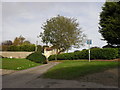
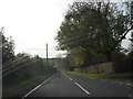
10
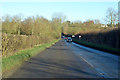
B4019 Cricklade Road towards Highworth
This road was a bit slippery in the shade.
Image: © Robin Webster
Taken: 19 Jan 2020
0.17 miles