IMAGES TAKEN NEAR TO
Shrivenham Road, SWINDON, SN6 7QQ
Introduction
This page details the photographs taken nearby to Shrivenham Road, SN6 7QQ by members of the Geograph project.
The Geograph project started in 2005 with the aim of publishing, organising and preserving representative images for every square kilometre of Great Britain, Ireland and the Isle of Man.

There are currently over 7.5m images from over14,400 individuals and you can help contribute to the project by visiting https://www.geograph.org.uk
Image Map (Loading...)


Getting Data...Please wait
Leaflet Map data © OpenStreetMap
Images are licensed for reuse under creativecommons.org/licenses/by-sa/2.0
Notes
- Clicking on the map will re-center to the selected point.
- The higher the marker number, the further away the image location is from the centre of the postcode.
Image Listing (7 Images Found)
Images are licensed for reuse under creativecommons.org/licenses/by-sa/2.0
Image
Details
Distance
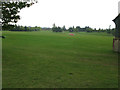
1
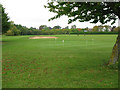
Golf course at Wrag Barn on the Shrivenham Road
Image: © Nick Smith
Taken: 24 Sep 2011
0.08 miles
2
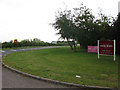
Junction of the road from Wrag Barn on to the B4000 Shrivenham Road
Image: © Nick Smith
Taken: 24 Sep 2011
0.12 miles
3
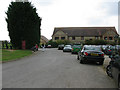
Wrag Barn golf and country club clubhouse
Just off the B4000 Shrivenham Road, see http://www.wragbarn.com/ for more information
Image: © Nick Smith
Taken: 24 Sep 2011
0.15 miles
4
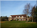
Wrag Barn Golf & Country Club, Shrivenham Road, Highworth
Wrag Barn, club house of the golf and country club. The club offers a golf course and academy, pro shop, conference facilities, and a venue for weddings, parties, and even wakes. A bridleway and a footpath cross the park, making it an attractive place for walkers and riders.
Image: © Vieve Forward
Taken: 7 Dec 2016
0.16 miles
5
View across the golf course at Wrag Barn
Image: © Nick Smith
Taken: 24 Sep 2011
0.20 miles
6
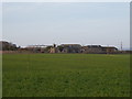
The Buildings
Partly ruined farm buildings, photographed on zoom from Shrivenham Road.
Image: © Vieve Forward
Taken: 7 Dec 2016
0.23 miles
7
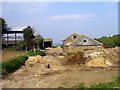
Eastrop Farm Outbuildings
This group of sheds and barns are part of Eastrop Farm which is NE of here.
Mainly used for cows, it's a bit messy up here.
This is a good day, you should see it when it's wet.
Image: © Des Blenkinsopp
Taken: 9 Jul 2008
0.24 miles