IMAGES TAKEN NEAR TO
Blackworth Industrial Estate, SWINDON, SN6 7NS
Introduction
This page details the photographs taken nearby to Blackworth Industrial Estate, SN6 7NS by members of the Geograph project.
The Geograph project started in 2005 with the aim of publishing, organising and preserving representative images for every square kilometre of Great Britain, Ireland and the Isle of Man.

There are currently over 7.5m images from over14,400 individuals and you can help contribute to the project by visiting https://www.geograph.org.uk
Image Map
Images are licensed for reuse under creativecommons.org/licenses/by-sa/2.0
Notes
- Clicking on the map will re-center to the selected point.
- The higher the marker number, the further away the image location is from the centre of the postcode.
Image Listing (5 Images Found)
Images are licensed for reuse under creativecommons.org/licenses/by-sa/2.0
Image
Details
Distance
1
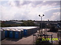
Portable toilets in Elliott Loohire depot
Image: © chris almond
Taken: 25 Sep 2008
0.01 miles
2
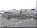
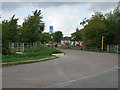
Industrial estate north of Highworth
Image: © Jonathan Billinger
Taken: 4 Jan 2007
0.03 miles
3
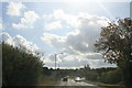
Approaching Highworth
From the north on the A361.
Image: © andrew auger
Taken: 10 Oct 2009
0.12 miles
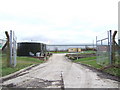
5
Pentylands Lane, no through road from Blackworth
The lane leads ultimately to Pentylands Farm.
Image: © Nick Smith
Taken: 24 Sep 2011
0.20 miles