IMAGES TAKEN NEAR TO
Utah Court, SN6 7FL
Introduction
This page details the photographs taken nearby to Utah Court, SN6 7FL by members of the Geograph project.
The Geograph project started in 2005 with the aim of publishing, organising and preserving representative images for every square kilometre of Great Britain, Ireland and the Isle of Man.

There are currently over 7.5m images from over14,400 individuals and you can help contribute to the project by visiting https://www.geograph.org.uk
Image Map (Loading...)


Getting Data...Please wait
Leaflet Map data © OpenStreetMap
Images are licensed for reuse under creativecommons.org/licenses/by-sa/2.0
Notes
- Clicking on the map will re-center to the selected point.
- The higher the marker number, the further away the image location is from the centre of the postcode.
Image Listing (17 Images Found)
Images are licensed for reuse under creativecommons.org/licenses/by-sa/2.0
Image
Details
Distance
1
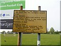
None of these
A notice at the entrance to the recreation ground.
Image: © Michael Dibb
Taken: 18 Apr 2019
0.11 miles
2
![Listed milestone [1]](https://s1.geograph.org.uk/geophotos/06/16/53/6165357_b7395730_120x120.jpg)
Listed milestone [1]
Located in Swindon Road [A361] this late 18th or early 19th century milestone reads Lechlade 5, Swindon 6. The milestone in context is at Image Listed, grade II, with details at: https://historicengland.org.uk/listing/the-list/list-entry/1023379
Image: © Michael Dibb
Taken: 18 Apr 2019
0.12 miles
3
![Listed milestone [2]](https://s1.geograph.org.uk/geophotos/06/16/53/6165361_ca33eb08_120x120.jpg)
Listed milestone [2]
The milestone seen at Image seen here in context. The road is Swindon Road, the A361. The milestone is listed, grade II, with details at: https://historicengland.org.uk/listing/the-list/list-entry/1023379
Image: © Michael Dibb
Taken: 18 Apr 2019
0.12 miles
4
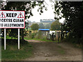
Clear instruction to keep allotment entrance clear.
The allotments are to the south of the Highworth football club grounds.
Image: © Nick Smith
Taken: 24 Sep 2011
0.12 miles
5
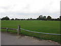
Football pitches at Highworth playing fields
Image: © Nick Smith
Taken: 24 Sep 2011
0.12 miles
6
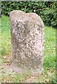
Old Milestone by the A361, Swindon Road, Highworth
Swindon half-round stone by the A361, in parish of Highworth (Swindon District), Swindon Road, opposite No. 10, Highworth Golf Centre, South of Shell Garage, on well kept grass in front of tall hedge.
Inscription once read:-
: (Lechlade / 5) : : (Swindon / 6) :
Grade II listed.
List Entry Number: 1023379 https://historicengland.org.uk/listing/the-list/list-entry/1023379
Surveyed
Milestone Society National ID: WI_SNLC06
Image: © Milestone Society
Taken: Unknown
0.13 miles
7
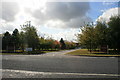
Entrance to Wrag Barn golf club
South of Highworth.
Image: © andrew auger
Taken: 10 Oct 2009
0.15 miles
8
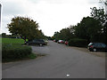
Car parking and access road for Highworth Football Club
Image: © Nick Smith
Taken: 24 Sep 2011
0.15 miles
9
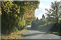
Shrivenham Road, Highworth
The B4000. taken heading away from the town centre.
Image: © andrew auger
Taken: 10 Oct 2009
0.16 miles
10
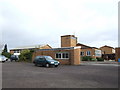
Highworth Warneford School
A mixed secondary school of 1960's origin.
Image: © Jonathan Billinger
Taken: 4 Jan 2007
0.19 miles