IMAGES TAKEN NEAR TO
Squires Court, SWINDON, SN6 7FH
Introduction
This page details the photographs taken nearby to Squires Court, SN6 7FH by members of the Geograph project.
The Geograph project started in 2005 with the aim of publishing, organising and preserving representative images for every square kilometre of Great Britain, Ireland and the Isle of Man.

There are currently over 7.5m images from over14,400 individuals and you can help contribute to the project by visiting https://www.geograph.org.uk
Image Map (Loading...)


Getting Data...Please wait
Leaflet Map data © OpenStreetMap
Images are licensed for reuse under creativecommons.org/licenses/by-sa/2.0
Notes
- Clicking on the map will re-center to the selected point.
- The higher the marker number, the further away the image location is from the centre of the postcode.
Image Listing (219 Images Found)
Images are licensed for reuse under creativecommons.org/licenses/by-sa/2.0
Image
Details
Distance
1
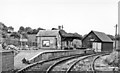
Highworth station, 1950
View eastward to the buffer-stops of the terminus of the ex-GWR branch from Swindon (Highworth Junction), closed to passengers 2/3/53, to goods 6/8/62. (See also my Image).
Image: © Walter Dendy, deceased
Taken: 24 Sep 1950
0.06 miles
2
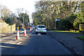
Road works on Cricklade Road, Highworth
The B4019.
Image: © Robin Webster
Taken: 19 Jan 2020
0.07 miles
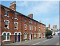
3
![Highworth houses [26]](https://s2.geograph.org.uk/geophotos/06/16/53/6165350_64fa19cc_120x120.jpg)
Highworth houses [26]
Number 24 Cricklade Road is circa 1818 and is listed, grade II, with details at: https://historicengland.org.uk/listing/the-list/list-entry/1023340
Image: © Michael Dibb
Taken: 18 Apr 2019
0.07 miles
4
![Highworth houses [31]](https://s3.geograph.org.uk/geophotos/06/16/53/6165347_d95f7e45_120x120.jpg)
Highworth houses [31]
Westrop House was built in 1878 for the Lord of the Manor. Many original fine internal features remain. Listed, grade II, with details at: https://historicengland.org.uk/listing/the-list/list-entry/1184675
Image: © Michael Dibb
Taken: 18 Apr 2019
0.08 miles
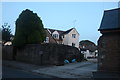
5
West Hill Villas, Cricklade Road
A terrace with distinctive doors and windows, although the windows get less distinctive as you go up.
The one on the far end can be seen in greater detail here Image
Image: © Des Blenkinsopp
Taken: 8 Aug 2020
0.10 miles
6
![Highworth houses [30]](https://s2.geograph.org.uk/geophotos/06/16/53/6165346_02997173_120x120.jpg)
Highworth houses [30]
Numbers 4 and 6 Cricklade Road unusually have shutters covering the (presumably) blind central windows.
Image: © Michael Dibb
Taken: 18 Apr 2019
0.10 miles
7
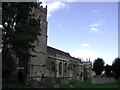
Highworth, Wiltshire
The parish church of St Michael in this hilltop market town north of Swindon bristles with pinnacles!
Image: © ChurchCrawler
Taken: 30 Aug 2004
0.11 miles
8
![Highworth buildings [46]](https://s0.geograph.org.uk/geophotos/06/16/22/6162292_fcf141ea_120x120.jpg)
Highworth buildings [46]
Formerly The Jesmond Hotel, now The Highworth Hotel, this fine building is dated 1721 and is listed, grade II*, with details at: https://historicengland.org.uk/listing/the-list/list-entry/1023386
Image: © Michael Dibb
Taken: 18 Apr 2019
0.11 miles
9
![Highworth buildings [57]](https://s1.geograph.org.uk/geophotos/06/16/53/6165345_699176ed_120x120.jpg)
Highworth buildings [57]
The right part is number 2 Westrop and is an annex to The Highworth Hotel (formerly The Jesmond Hotel). Built in the mid 18th century and listed, grade II, with details at: https://historicengland.org.uk/listing/the-list/list-entry/1185140
The left part is number 2 Cricklade Road and is 18th century. Listed, grade II, with details at: https://historicengland.org.uk/listing/the-list/list-entry/1023339
Image: © Michael Dibb
Taken: 18 Apr 2019
0.11 miles
10
Cricklade Road, Highworth
Looking towards the rear of the High Street
Image: © David Howard
Taken: 10 Aug 2019
0.11 miles