IMAGES TAKEN NEAR TO
The Paddock, SWINDON, SN6 7AR
Introduction
This page details the photographs taken nearby to The Paddock, SN6 7AR by members of the Geograph project.
The Geograph project started in 2005 with the aim of publishing, organising and preserving representative images for every square kilometre of Great Britain, Ireland and the Isle of Man.

There are currently over 7.5m images from over14,400 individuals and you can help contribute to the project by visiting https://www.geograph.org.uk
Image Map (Loading...)


Getting Data...Please wait
Leaflet Map data © OpenStreetMap
Images are licensed for reuse under creativecommons.org/licenses/by-sa/2.0
Notes
- Clicking on the map will re-center to the selected point.
- The higher the marker number, the further away the image location is from the centre of the postcode.
Image Listing (232 Images Found)
Images are licensed for reuse under creativecommons.org/licenses/by-sa/2.0
Image
Details
Distance
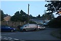
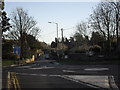
2
Mini roundabouts in Highworth
The B4019 from Faringdon arriving in Highworth.
Image: © andrew auger
Taken: 20 Dec 2009
0.01 miles
3
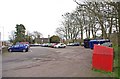
Public car park, Brewery Street, Highworth
This public car park is on the corner of Brewery Street, and Eastrop, with the vehicular access from Brewery Street. It contains a small recycling facility, which can be seen on the right.
Image: © P L Chadwick
Taken: 11 Mar 2011
0.02 miles
4
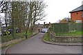
Park Avenue, Highworth
This is the older part of Park Avenue, with some old cottages.
Image: © P L Chadwick
Taken: 11 Mar 2011
0.03 miles
5
![Highworth houses [4]](https://s3.geograph.org.uk/geophotos/06/15/90/6159027_343402eb_120x120.jpg)
Highworth houses [4]
Boreas Cottage is late 18th century or possibly earlier, altered in the 19th century. The cottage has some original internal features. Listed, grade II, with details at: https://historicengland.org.uk/listing/the-list/list-entry/1023369
Image: © Michael Dibb
Taken: 18 Apr 2019
0.03 miles
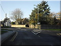
6
Approaching the mini roundabouts on Highworth high street
The B4019 to Faringdon is straight ahead.
Image: © andrew auger
Taken: 20 Dec 2009
0.04 miles
7
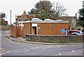
Public convenience, Brewery Street, Highworth
This modern public convenience is across the road from the Brewery Street public car park, which really is convenient!
Image: © P L Chadwick
Taken: 11 Mar 2011
0.04 miles
8
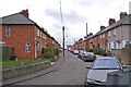
Park Avenue, Highworth
This part of Park Avenue was built in 1925 for the former Highworth Rural District Council. It was what is now called social housing, but used to be called council housing. Many of these houses have been sold off into private ownership.
Image: © P L Chadwick
Taken: 11 Mar 2011
0.05 miles
9
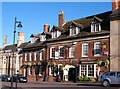
The Saracen's Head Hotel
Former coaching inn on Highworth's High Street. Now a pub with a few letting rooms.
Image: © Gordon Hatton
Taken: 3 Jun 2010
0.05 miles
10
![Highworth houses [33]](https://s2.geograph.org.uk/geophotos/06/16/55/6165574_76a9797d_120x120.jpg)
Highworth houses [33]
Park Avenue, Highworth.
Image: © Michael Dibb
Taken: 18 Apr 2019
0.06 miles