IMAGES TAKEN NEAR TO
Roundhills Mead, SWINDON, SN6 7AL
Introduction
This page details the photographs taken nearby to Roundhills Mead, SN6 7AL by members of the Geograph project.
The Geograph project started in 2005 with the aim of publishing, organising and preserving representative images for every square kilometre of Great Britain, Ireland and the Isle of Man.

There are currently over 7.5m images from over14,400 individuals and you can help contribute to the project by visiting https://www.geograph.org.uk
Image Map
Images are licensed for reuse under creativecommons.org/licenses/by-sa/2.0
Notes
- Clicking on the map will re-center to the selected point.
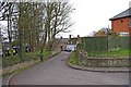
- The higher the marker number, the further away the image location is from the centre of the postcode.
Image Listing (234 Images Found)
Images are licensed for reuse under creativecommons.org/licenses/by-sa/2.0
Image
Details
Distance
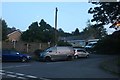
1
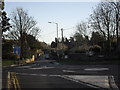
Approaching the mini roundabouts on Highworth high street
The B4019 to Faringdon is straight ahead.
Image: © andrew auger
Taken: 20 Dec 2009
0.04 miles
2
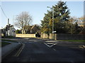
Mini roundabouts in Highworth
The B4019 from Faringdon arriving in Highworth.
Image: © andrew auger
Taken: 20 Dec 2009
0.04 miles
3
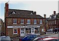
Highworth Emporium (1), 46 High Street, Highworth
This is a family run gift shop, which also has an online internet business. The business has two frontages, one (shown here) is onto Market Place, and the other, around the corner, is onto High Street.
Image
Image: © P L Chadwick
Taken: 11 Mar 2011
0.04 miles
4
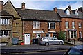
Highworth Emporium (2), 46 High Street, Highworth
The main entrance to this gift shop is around the corner in Market Place. The building the Highworth Emporium occupies, or part of it, was long ago in the early 17th century, an inn called the "Holy Lamb Inn". Later it was renamed the "King's Head". After ceasing to be an inn, it was for many years a grocer's shop.
Image
Image: © P L Chadwick
Taken: 11 Mar 2011
0.04 miles
6
![Highworth houses [3]](https://s2.geograph.org.uk/geophotos/06/15/90/6159026_4720591e_120x120.jpg)
Highworth houses [3]
The former Parsonage Farmhouse is now part of Parsonage Court housing development. Built circa 1700 and greatly altered circa 1900, this fine building is listed, grade II, with details at: https://historicengland.org.uk/listing/the-list/list-entry/1023343
Image: © Michael Dibb
Taken: 18 Apr 2019
0.05 miles
7
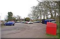
Public car park, Brewery Street, Highworth
This public car park is on the corner of Brewery Street, and Eastrop, with the vehicular access from Brewery Street. It contains a small recycling facility, which can be seen on the right.
Image: © P L Chadwick
Taken: 11 Mar 2011
0.05 miles
8
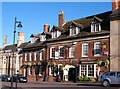
The Saracen's Head Hotel
Former coaching inn on Highworth's High Street. Now a pub with a few letting rooms.
Image: © Gordon Hatton
Taken: 3 Jun 2010
0.05 miles
9
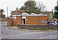
Public convenience, Brewery Street, Highworth
This modern public convenience is across the road from the Brewery Street public car park, which really is convenient!
Image: © P L Chadwick
Taken: 11 Mar 2011
0.05 miles
10
Park Avenue, Highworth
This is the older part of Park Avenue, with some old cottages.
Image: © P L Chadwick
Taken: 11 Mar 2011
0.05 miles