IMAGES TAKEN NEAR TO
Leigh, SWINDON, SN6 6RQ
Introduction
This page details the photographs taken nearby to SN6 6RQ by members of the Geograph project.
The Geograph project started in 2005 with the aim of publishing, organising and preserving representative images for every square kilometre of Great Britain, Ireland and the Isle of Man.

There are currently over 7.5m images from over14,400 individuals and you can help contribute to the project by visiting https://www.geograph.org.uk
Image Map
Images are licensed for reuse under creativecommons.org/licenses/by-sa/2.0
Notes
- Clicking on the map will re-center to the selected point.
- The higher the marker number, the further away the image location is from the centre of the postcode.
Image Listing (6 Images Found)
Images are licensed for reuse under creativecommons.org/licenses/by-sa/2.0
Image
Details
Distance
2
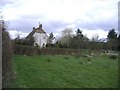
South Leigh farm
Has diversified into self-catering holiday accommodation.
Image: © Roger Cornfoot
Taken: 8 Mar 2007
0.06 miles
5
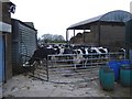
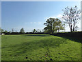
Leighfield farm
Cows are penned, prior to milking at this farm, near Minety.
Image: © Roger Cornfoot
Taken: 17 Jan 2007
0.21 miles
6
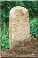
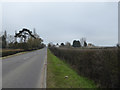
Old Milestone by the B4040, west of Leigh Cross Roads
Malmesbury triangle milestone by the B4040, in parish of Leigh (North Wiltshire District), West of Leigh Cross Roads with B4696, by the South side of road.
Inscription once read:-
(Cricklade)
(4)
(Malmesbury)
(8)
Grade II listed.
List Entry Number: 1023139 https://historicengland.org.uk/listing/the-list/list-entry/1023139
To be surveyed
Milestone Society National ID: WI_myck08
Image: © Milestone Society
Taken: Unknown
0.25 miles