IMAGES TAKEN NEAR TO
Cotswold Community, SWINDON, SN6 6QT
Introduction
This page details the photographs taken nearby to Cotswold Community, SN6 6QT by members of the Geograph project.
The Geograph project started in 2005 with the aim of publishing, organising and preserving representative images for every square kilometre of Great Britain, Ireland and the Isle of Man.

There are currently over 7.5m images from over14,400 individuals and you can help contribute to the project by visiting https://www.geograph.org.uk
Image Map
Images are licensed for reuse under creativecommons.org/licenses/by-sa/2.0
Notes
- Clicking on the map will re-center to the selected point.
- The higher the marker number, the further away the image location is from the centre of the postcode.
Image Listing (5 Images Found)
Images are licensed for reuse under creativecommons.org/licenses/by-sa/2.0
Image
Details
Distance
1
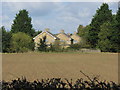
Boarded-up houses near the Cotswold Community
Image: © Gareth James
Taken: 21 Sep 2014
0.01 miles
3
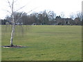
Playing field Cotswold Community, Ashton Keynes
The Cotswold Community School is currently run by NCH (National Children's Homes). It has had other school uses and was originally built by the Bruderhof, a group that left Germany before the war, and subsequently moved to South America
Image: © Peter Watkins
Taken: 26 Feb 2006
0.10 miles