IMAGES TAKEN NEAR TO
Milling Close, SWINDON, SN6 6PT
Introduction
This page details the photographs taken nearby to Milling Close, SN6 6PT by members of the Geograph project.
The Geograph project started in 2005 with the aim of publishing, organising and preserving representative images for every square kilometre of Great Britain, Ireland and the Isle of Man.

There are currently over 7.5m images from over14,400 individuals and you can help contribute to the project by visiting https://www.geograph.org.uk
Image Map (Loading...)


Getting Data...Please wait
Leaflet Map data © OpenStreetMap
Images are licensed for reuse under creativecommons.org/licenses/by-sa/2.0
Notes
- Clicking on the map will re-center to the selected point.
- The higher the marker number, the further away the image location is from the centre of the postcode.
Image Listing (29 Images Found)
Images are licensed for reuse under creativecommons.org/licenses/by-sa/2.0
Image
Details
Distance
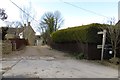
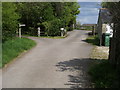
1
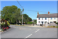
Ashton Keynes
Junction of Fore Street and Kent End.
Image: © Wayland Smith
Taken: 25 May 2020
0.06 miles
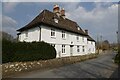
2
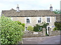
Park End, Ashton Keynes
Old Cotswold stone cottage in a delightful village near Cricklade.
http://www.ashtonkeynes.org.uk/public/index.asp
Image: © Colin Smith
Taken: 16 Jul 2009
0.07 miles
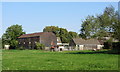
4
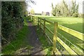
The Thames Path entering Ashton Keynes
The Thames Path passing Kentend Farm as it enters Ashton Keynes.
Image: © Philip Halling
Taken: 25 Mar 2022
0.15 miles
6
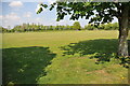
Playing field at Ashton Keynes
A Saturday afternoon football match on a playing field at Ashton Keynes
Image: © Philip Halling
Taken: 23 Apr 2011
0.17 miles
7
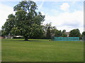
High Road Recreation Ground
High Road recreation ground Ashton Keynes
Image: © Shaun Ferguson
Taken: 15 May 2010
0.18 miles
9
Thames Path
Thames Path by Kent End Farm
Image: © Shaun Ferguson
Taken: 15 May 2010
0.19 miles
10
Former pub on Back Street
There is a Best in the West plaque on this building which indicates this was once a public house. There is a date on the front of 1694.
Image: © Philip Halling
Taken: 25 Mar 2022
0.19 miles