IMAGES TAKEN NEAR TO
Keels, SWINDON, SN6 6NB
Introduction
This page details the photographs taken nearby to Keels, SN6 6NB by members of the Geograph project.
The Geograph project started in 2005 with the aim of publishing, organising and preserving representative images for every square kilometre of Great Britain, Ireland and the Isle of Man.

There are currently over 7.5m images from over14,400 individuals and you can help contribute to the project by visiting https://www.geograph.org.uk
Image Map (Loading...)


Getting Data...Please wait
Leaflet Map data © OpenStreetMap
Images are licensed for reuse under creativecommons.org/licenses/by-sa/2.0
Notes
- Clicking on the map will re-center to the selected point.
- The higher the marker number, the further away the image location is from the centre of the postcode.
Image Listing (27 Images Found)
Images are licensed for reuse under creativecommons.org/licenses/by-sa/2.0
Image
Details
Distance
1
![A circular walk around Cricklade [10]](https://s1.geograph.org.uk/geophotos/06/33/74/6337437_bed64242_120x120.jpg)
A circular walk around Cricklade [10]
The path, here part of two long distance paths - the Thames Path and the Thames and Severn Way - crosses a ditch just before it crosses the River Thames.
Starting in the town of Cricklade, the walk passes through Latton and Eysey before following the River Thames back to Cricklade.
Image: © Michael Dibb
Taken: 25 Aug 2019
0.06 miles
2
![A circular walk around Cricklade [8]](https://s3.geograph.org.uk/geophotos/06/33/74/6337435_4db5b8e5_120x120.jpg)
A circular walk around Cricklade [8]
The path, here part of two long distance paths - the Thames Path and the Thames and Severn Way - heads past Quendale House towards West Mill Lane and the River Thames.
Starting in the town of Cricklade, the walk passes through Latton and Eysey before following the River Thames back to Cricklade.
Image: © Michael Dibb
Taken: 25 Aug 2019
0.06 miles
3
![A circular walk around Cricklade [7]](https://s2.geograph.org.uk/geophotos/06/33/74/6337434_24f5dbcd_120x120.jpg)
A circular walk around Cricklade [7]
The path, here part of two long distance paths - the Thames Path and the Thames and Severn Way - runs across the field towards the poplars.
Starting in the town of Cricklade, the walk passes through Latton and Eysey before following the River Thames back to Cricklade.
Image: © Michael Dibb
Taken: 25 Aug 2019
0.07 miles
4
![A circular walk around Cricklade [9]](https://s0.geograph.org.uk/geophotos/06/33/74/6337436_a8dc987d_120x120.jpg)
A circular walk around Cricklade [9]
The path, here part of two long distance paths - the Thames Path and the Thames and Severn Way - passes some farm buildings just before it crosses the River Thames.
Starting in the town of Cricklade, the walk passes through Latton and Eysey before following the River Thames back to Cricklade.
Image: © Michael Dibb
Taken: 25 Aug 2019
0.07 miles
5
![A circular walk around Cricklade [11]](https://s2.geograph.org.uk/geophotos/06/33/74/6337438_4e25f245_120x120.jpg)
A circular walk around Cricklade [11]
The River Thames seen from the bridge carrying the path, here part of two long distance paths - the Thames Path and the Thames and Severn Way.
Starting in the town of Cricklade, the walk passes through Latton and Eysey before following the River Thames back to Cricklade.
Image: © Michael Dibb
Taken: 25 Aug 2019
0.08 miles
6
Field shelter incorporating an old trailer or container
Near the weir on R. Thames.
Image: © Liz Stone
Taken: 22 Mar 2012
0.08 miles
7
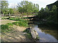
River Thames
River Thames and Thames Path at the bridge at West Mill Lane
Image: © Shaun Ferguson
Taken: 15 May 2010
0.09 miles
8
![A circular walk around Cricklade [12]](https://s3.geograph.org.uk/geophotos/06/33/74/6337439_e0c69028_120x120.jpg)
A circular walk around Cricklade [12]
Now on the north bank of the River Thames the path, here part of two long distance paths - the Thames Path and the Thames and Severn Way - runs through this field with horses.
Starting in the town of Cricklade, the walk passes through Latton and Eysey before following the River Thames back to Cricklade.
Image: © Michael Dibb
Taken: 25 Aug 2019
0.09 miles
9
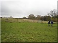
North Wilts Canal
Looking in the other direction from Image Here the canal line has been almost filled in and the route can only be traced by the slight change in contours of the field.
Image: © David Stowell
Taken: 5 Nov 2008
0.09 miles
10
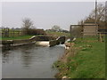
Thames weir near Cricklade
Two levels of weir and metering equipment in the small building.
Image: © Liz Stone
Taken: 22 Mar 2012
0.09 miles