IMAGES TAKEN NEAR TO
Marston Meysey, SWINDON, SN6 6LL
Introduction
This page details the photographs taken nearby to SN6 6LL by members of the Geograph project.
The Geograph project started in 2005 with the aim of publishing, organising and preserving representative images for every square kilometre of Great Britain, Ireland and the Isle of Man.

There are currently over 7.5m images from over14,400 individuals and you can help contribute to the project by visiting https://www.geograph.org.uk
Image Map (Loading...)


Getting Data...Please wait
Leaflet Map data © OpenStreetMap
Images are licensed for reuse under creativecommons.org/licenses/by-sa/2.0
Notes
- Clicking on the map will re-center to the selected point.
- The higher the marker number, the further away the image location is from the centre of the postcode.
Image Listing (16 Images Found)
Images are licensed for reuse under creativecommons.org/licenses/by-sa/2.0
Image
Details
Distance
1
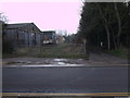
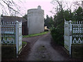
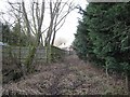
Public footpath to Marston Meysey Roundhouse
The public footpath to Marston Meysey Roundhouse (see Image]) leads, not down the drive, but through the farmyard, as the notice on the drive gate makes clear. It rejoins the drive at a stile fifty metres further down. The entrance to the footpath is not marked on the gate to the farmyard, and access is gained by slipping through an unmarked gap in the fence to the side.
Image: © Vieve Forward
Taken: 16 Feb 2013
0.03 miles
2
Round House farm
On the minor road from Kempsford to Cricklade.
Image: © Roger Cornfoot
Taken: 5 Feb 2007
0.04 miles
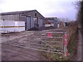
3
Drive at Round House Farm
This private drive leads to the disused canal round house.
Image: © David Smith
Taken: 28 Dec 2012
0.04 miles
4
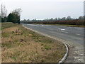
The road to the A419, near Marston Meysey
The road has been widened at this location to provide a safer access to a new gravel bed. The A419 is about 4 kilometres further on.
Image: © Brian Robert Marshall
Taken: 27 Jan 2009
0.11 miles
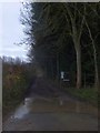
5
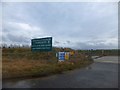
Entrance to new gravel works near Marston Meysey
The quarries do not appear on maps yet, although they are on Google streetview
Image: © David Smith
Taken: 28 Dec 2012
0.11 miles
6
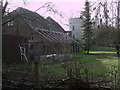
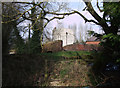
Former canal roundhouse and bridge on the disused Thames & Severn Canal near Marston Meysey
Grade II Listed former canal roundhouse and bridge on the disused Thames & Severn Canal http://en.wikipedia.org/wiki/Thames_and_Severn_Canal near Marston Meysey. http://www.cotswoldcanals.com/pages/locks-bridges-structures/bridges-and-buildings.php
The roundhouse http://www.britishlistedbuildings.co.uk/en-317896-round-house-marston-maisey- is one of five famous former lengthsmen’s cottages on the Thames & Severn Canal. It was built circa 1790. Although the listing describes it as being constructed of pebbledashed brick with limestone dressings to doors and windows, a survey for the Cotswold Canals Project says that it was built of rendered rubblestone with ashlar band courses at the upper floor levels and stone ‘Gothic’ surrounds to windows and doors. http://www.cotswoldcanalsproject.org/_documents/2_HS_241-258_Marston_Meysey_Bridge.pdf It originally had a funnel-shaped lead roof to channel rainwater for use in the cottage. The ground floor was used for stabling, with the upper two for living accommodation. There is a fireplace on the first floor and a staircase to the top floor within the wall thickness. When the canal company no longer needed the building after the lengthsman had been transferred to a new house at Eisey Lock in 1831 (see Image]), the roundhouse became derelict.
Marston Meysey bridge (seen here just to the right of the roundhouse, see also Image]) is a Grade II Listed accommodation bridge http://www.britishlistedbuildings.co.uk/en-317897-marston-meysey-bridge-marston-maisey- over the disused Thames & Severn Canal, built at the end of the 18th century at the point where the towpath formerly crossed over the canal. The bridge is built in red brick with stone copings and stone springers for three rings of half-brick arches. As well as including a gatepier, the listing mentions traces of a former lock below the bridge, but Cotswold Canals Trust does not list a lock between Eysey Lock (no.41) and Dudgrove double lock (nos. 42 & 43). http://www.cotswoldcanals.com/pages/locks-bridges-structures/bridges-and-buildings.php A picture of the bridge showing what might be construed as the remains of a lock can be seen at http://www.cotswoldcanalsproject.org/_documents/2_HS_241-258_Marston_Meysey_Bridge.pdf
In 1986 an 'extension' was added to the roundhouse. Both bridge and roundhouse are now in the grounds of private property, and the footpath has long since been re-routed. http://www.cotswoldcanals.net/rh_mm.php At the time of my visit, the only viable footpath in the vicinity was that running south to them from the road; the footpaths leading away north-west and east having both been rendered impassable or maybe even destroyed by gravel extraction.
Image: © Vieve Forward
Taken: 16 Feb 2013
0.13 miles
7
Former canal roundhouse on the disused Thames & Severn Canal near Marston Meysey
Grade II Listed former canal roundhouse on the disused Thames & Severn Canal http://en.wikipedia.org/wiki/Thames_and_Severn_Canal near Marston Meysey, (see also Image]). The roundhouse http://www.britishlistedbuildings.co.uk/en-317896-round-house-marston-maisey- is one of five famous former lengthsmen’s cottages on the Thames & Severn Canal. It was built circa 1790. Although the listing describes it as being constructed of pebbledashed brick with limestone dressings to doors and windows, a survey for the Cotswold Canals Project says that it was built of rendered rubblestone with ashlar band courses at the upper floor levels. This photograph shows the ‘Gothic’-style windows. http://www.cotswoldcanalsproject.org/_documents/2_HS_241-258_Marston_Meysey_Bridge.pdf It originally had a funnel-shaped lead roof to channel rainwater for use in the cottage. The ground floor was used for stabling, with the upper two for living accommodation. There is a fireplace on the first floor and a staircase to the top floor within the wall thickness. When the canal company no longer needed the building after the lengthsman had been transferred to a new house at Eisey Lock in 1831 (see Image]), the roundhouse became derelict. Out of the picture on the other side of the roundhouse is Marston Meysey bridge, a Grade II Listed accommodation bridge http://www.britishlistedbuildings.co.uk/en-317897-marston-meysey-bridge-marston-maisey- over the disused Thames & Severn Canal (see also Image]).
In 1986 an 'extension' was added to the roundhouse. Both bridge and roundhouse are now in the grounds of private property, and the footpath has long since been re-routed around them. http://www.cotswoldcanals.net/rh_mm.php At the time of my visit, the only viable public footpath in the vicinity was this one running south to them from the road and around the north-east of the property.
Image: © Vieve Forward
Taken: 16 Feb 2013
0.13 miles
8
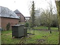
Marston Meysey Lock
The Thames and Severn Canal lock at Marston Meysey is now fenced off and in private ownership. It is still possible however to see the distinctive lock keeper's roundhouse, a unique characteristic of the Thames and Severn Canal, from the adjacent Public Footpath.
Image: © David Stowell
Taken: 21 Jan 2009
0.15 miles
9
Thames and Severn Canal at Marston Meysey
The Thames and Severn Canal lock at Marston Meysey is now fenced off and in private ownership and hidden behind this fencing, as seen from the adjoining public footpath. Restoration of the canal past this point will probably require a small diversion, although compared with some of the other challenges to be addressed this is probably a relatively minor inconvenience.
Image: © David Stowell
Taken: 21 Jan 2009
0.15 miles
10
Bridge and roundhouse on the disused Thames & Severn Canal near Marston Meysey
Grade II Listed hump-backed bridge and former canal roundhouse on the disused Thames & Severn canal http://en.wikipedia.org/wiki/Thames_and_Severn_Canal near Marston Meysey. http://www.cotswoldcanals.com/pages/locks-bridges-structures/bridges-and-buildings.php
Marston Meysey bridge is a Grade II Listed accommodation bridge http://www.britishlistedbuildings.co.uk/en-317897-marston-meysey-bridge-marston-maisey- over the disused Thames & Severn Canal, built at the end of the 18th century at the point where the towpath formerly crossed over the canal. The bridge is built in red brick with stone copings and stone springers for three rings of half-brick arches. As well as including a gatepier, the listing mentions traces of a former lock below the bridge, but Cotswold Canals Trust does not list a lock between Eysey Lock (no.41) and Dudgrove double lock (nos. 42 & 43). http://www.cotswoldcanals.com/pages/locks-bridges-structures/bridges-and-buildings.php A picture of the bridge showing what might be construed as the remains of a lock can be seen at http://www.cotswoldcanalsproject.org/_documents/2_HS_241-258_Marston_Meysey_Bridge.pdf
The Grade II Listed roundhouse, see also Image], is one of five famous former lengthsmen’s cottages on the Thames & Severn Canal. It was built circa 1790. Although the listing http://www.britishlistedbuildings.co.uk/en-317896-round-house-marston-maisey- describes it as being constructed of pebbledashed brick with limestone dressings to doors and windows, a survey for the Cotswold Canals Project says that it was built of rendered rubblestone with ashlar band courses at the upper floor levels and stone ‘Gothic’ surrounds to windows and doors. http://www.cotswoldcanalsproject.org/_documents/2_HS_241-258_Marston_Meysey_Bridge.pdf It originally had a funnel-shaped lead roof to channel rainwater for use in the cottage. The ground floor was used for stabling, with the upper two for living accommodation. There is a fireplace on the first floor and a staircase to the top floor within the wall thickness. When the canal company no longer needed the building after the lengthsman had been transferred to a new house at Eisey Lock in 1831 (see Image]), the roundhouse became derelict.
In 1986 an 'extension' was added to the roundhouse. Both bridge and roundhouse are now in the grounds of private property, and the footpath has long since been re-routed. http://www.cotswoldcanals.net/rh_mm.php At the time of my visit, the only viable footpath in the vicinity was that running south to them from the road; the footpaths leading away north-west and east having both been rendered impassable or maybe even destroyed by gravel extraction.
Image: © Vieve Forward
Taken: 16 Feb 2013
0.15 miles