IMAGES TAKEN NEAR TO
Marston Meysey, SWINDON, SN6 6LG
Introduction
This page details the photographs taken nearby to SN6 6LG by members of the Geograph project.
The Geograph project started in 2005 with the aim of publishing, organising and preserving representative images for every square kilometre of Great Britain, Ireland and the Isle of Man.

There are currently over 7.5m images from over14,400 individuals and you can help contribute to the project by visiting https://www.geograph.org.uk
Image Map (Loading...)


Getting Data...Please wait
Leaflet Map data © OpenStreetMap
Images are licensed for reuse under creativecommons.org/licenses/by-sa/2.0
Notes
- Clicking on the map will re-center to the selected point.
- The higher the marker number, the further away the image location is from the centre of the postcode.
Image Listing (13 Images Found)
Images are licensed for reuse under creativecommons.org/licenses/by-sa/2.0
Image
Details
Distance
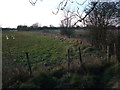
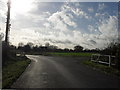
1
Blackburr Farm, Castle Eaton
A collection of barns and sheds north of the village.
Image: © Des Blenkinsopp
Taken: 20 Jun 2022
0.02 miles
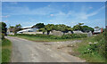
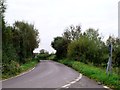
3
Un-named lane junction south of Blackburr Farm
Image: © Stuart Logan
Taken: 13 Apr 2014
0.12 miles
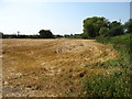
5
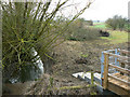
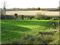
Drain, north of Castle Eaton
The drain flows away from the viewpoint to the west where it connects with the River Thames just outside this square. The steps and gate mark the start of a footpath to Marston Meysey.
Image: © Brian Robert Marshall
Taken: 27 Jan 2009
0.15 miles
7
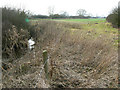
Not the Thames near Castle Eaton, Wiltshire
Not on a ride along the Thames path. The nearest the river Thames is to this point is about 250 metres south and the Thames Path doesn't pass through this square. This is a drain which flows from the east to the west in the direction of view to the Thames, which it joins at SU14009599.
Image: © Brian Robert Marshall
Taken: 27 Jan 2009
0.16 miles
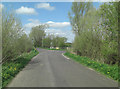
8
Looking W across fields from church
The reverse view of http://www.geograph.org.uk/photo/1559018
Image: © Nick Smith
Taken: 26 Oct 2009
0.23 miles
9
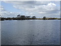
Isis in flood 4
View from the bridge at Castle Eaton showing the full extent of the March 2007 floods.
Image: © Jonathan Billinger
Taken: 7 Mar 2007
0.23 miles