IMAGES TAKEN NEAR TO
Stones Lane, SWINDON, SN6 6JP
Introduction
This page details the photographs taken nearby to Stones Lane, SN6 6JP by members of the Geograph project.
The Geograph project started in 2005 with the aim of publishing, organising and preserving representative images for every square kilometre of Great Britain, Ireland and the Isle of Man.

There are currently over 7.5m images from over14,400 individuals and you can help contribute to the project by visiting https://www.geograph.org.uk
Image Map (Loading...)


Getting Data...Please wait
Leaflet Map data © OpenStreetMap
Images are licensed for reuse under creativecommons.org/licenses/by-sa/2.0
Notes
- Clicking on the map will re-center to the selected point.
- The higher the marker number, the further away the image location is from the centre of the postcode.
Image Listing (15 Images Found)
Images are licensed for reuse under creativecommons.org/licenses/by-sa/2.0
Image
Details
Distance
2
The northern shoulder of Hailstone Hill, near Cricklade
The hill is quite small by comparison with those found elswehere in the UK. It is about 15 metres in height measured from the Thames a few hundred metres to the north-west. This isn't quite the summit - there's another three metres or so to climb. I just hope I don't get altitude sickness when I reach it.
Image: © Brian Robert Marshall
Taken: 31 Jan 2011
0.13 miles
3

Peacock near Cricklade
The rear end of a peahen is visible at the right.
Image: © Brian Robert Marshall
Taken: 31 Jan 2011
0.15 miles
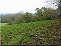
4
View north-west from Hailstone Hill, near Cricklade
The area roundabout is quite flat but there is a small hill that provides a viewpoint over the southern extremities of south-east Gloucestershire. The hedge at the extreme left marks the position of a bridleway.
Image: © Brian Robert Marshall
Taken: 31 Jan 2011
0.15 miles
5
View to Hailstone Hill
View to Hailstone Hill from the Thames Path; the River Thames passes through the meadowland in the middle distance.
Image: © Philip Halling
Taken: 23 Apr 2011
0.15 miles
6
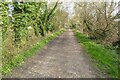
Former railway near Cricklade
This former railway trackbed near Cricklade is now a cycleway and footpath.
Image: © Philip Halling
Taken: 25 Mar 2022
0.16 miles
7
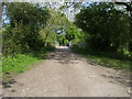
Thames Path
The Thames Path cuts off left here to follow the river whilst the old railway line crosses the river
Image: © Shaun Ferguson
Taken: 15 May 2010
0.19 miles
8
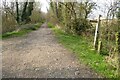
Sign for the Thames Path
Signpost on the trackbed on a former railway near Cricklade. The sign indicates the route of the Thames Path.
Image: © Philip Halling
Taken: 25 Mar 2022
0.19 miles
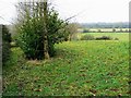
9
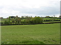
Farmland on Hailstorm Hill
Looking towards the (slightly higher) Common Hill.
Image: © David Purchase
Taken: 13 Apr 2017
0.19 miles
10
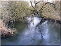
River Thames, near Hailstone Hill, Cricklade
This is a downstream view of the river as it leads towards the North Meadow National Nature Reserve. It also marks the boundary between Wiltshire, to the right, and Gloucestershire.
Image: © Brian Robert Marshall
Taken: 31 Jan 2011
0.20 miles