IMAGES TAKEN NEAR TO
Cricklade, SWINDON, SN6 6HU
Introduction
This page details the photographs taken nearby to SN6 6HU by members of the Geograph project.
The Geograph project started in 2005 with the aim of publishing, organising and preserving representative images for every square kilometre of Great Britain, Ireland and the Isle of Man.

There are currently over 7.5m images from over14,400 individuals and you can help contribute to the project by visiting https://www.geograph.org.uk
Image Map (Loading...)


Getting Data...Please wait
Leaflet Map data © OpenStreetMap
Images are licensed for reuse under creativecommons.org/licenses/by-sa/2.0
Notes
- Clicking on the map will re-center to the selected point.
- The higher the marker number, the further away the image location is from the centre of the postcode.
Image Listing (7 Images Found)
Images are licensed for reuse under creativecommons.org/licenses/by-sa/2.0
Image
Details
Distance
1
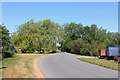
Bridge over the Key
Road bridge at Broadleaze Farm.
Image: © Wayland Smith
Taken: 25 May 2020
0.07 miles
2
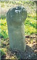
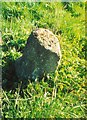
Old Milestone by the B4553, south of Broadleaze House
Purton column by the B4553, in parish of Cricklade (North Wiltshire District), South of crossroads at Broadleaze House, on wide grass verge. Position further North than that shown on OS map.
Inscription not clear.
Surveyed
Milestone Society National ID: WI_ckwb02
Image: © Milestone Society
Taken: Unknown
0.11 miles
3
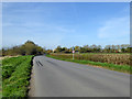
50 limited road
Wonder why the heavy braking?
Image: © Robin Webster
Taken: 25 Mar 2017
0.16 miles
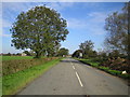
4
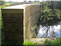
North Wilts Canal & River Key
The North Wilts Canal was the branch of the Wilts and Berks Canal that linked Swindon and Cricklade. The canal was abandoned in 1914 but ambitious plans have been drawn up to re-open it by the Wilts and Berks Canal Trust whose website is here http://www.wilts-berks-canal.org.uk/ This particular structure was the parapet wall of the aqueduct that carried the Canal over the River Key. The parapet has recently been refurbished, although the canal itself, behind the wall, remains filled in.
Image: © Nigel Cox
Taken: 24 Oct 2006
0.17 miles
5
Old Milestone by the B4553, Cricklade parish
Purton column by the B4553, in parish of Cricklade (North Wiltshire District), South of crossroads at Broadleaze House, on wide grass verge.
Surveyed
Milestone Society National ID: WI_ckwb01
Image: © Milestone Society
Taken: Unknown
0.17 miles
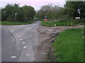
6
B4553 Cricklade Road
Viewed from north of Littleworth Bridge and looking towards Cricklade, the road is currently closed while the bridge is rebuilt.
Image: © Nigel Cox
Taken: 24 Oct 2006
0.19 miles
7
Shortcut from Cricklade
Minor road providing a shortcut between Cricklade and the road to Common Platt. NB. One way only!
Image: © Vieve Forward
Taken: 30 Apr 2014
0.21 miles