
IMAGES TAKEN NEAR TO
Byre Close, SWINDON, SN6 6HH
Introduction
This page details the photographs taken nearby to Byre Close, SN6 6HH by members of the Geograph project.
The Geograph project started in 2005 with the aim of publishing, organising and preserving representative images for every square kilometre of Great Britain, Ireland and the Isle of Man.

There are currently over 7.5m images from over14,400 individuals and you can help contribute to the project by visiting https://www.geograph.org.uk
Image Map
Images are licensed for reuse under creativecommons.org/licenses/by-sa/2.0
Notes
- Clicking on the map will re-center to the selected point.
- The higher the marker number, the further away the image location is from the centre of the postcode.
Image Listing (49 Images Found)
Images are licensed for reuse under creativecommons.org/licenses/by-sa/2.0
Image
Details
Distance
1

Path under the old railway bridge
Although the line has not seen a train for decades, the bridge remains - as does the path underneath it.
Image: © Neil Owen
Taken: 20 May 2025
0.04 miles
2

A quiet spot on the old railway line
Disused for decades, the railway line through Cricklade is now used for more homely purposes. All it needs is a small bar.
Image: © Neil Owen
Taken: 20 May 2025
0.04 miles
3

Peacock butterfly on a leaf, Cycle Route 45, Cricklade
The butterfly was flitting around all over the place before settling for a few seconds on the large leaf. This enabled me to take this rather hurried shot before it took off again.
Image: © Brian Robert Marshall
Taken: 3 May 2014
0.05 miles
4

Hedgehog highway
A small opening in the fencing allows the little creatures to progress through the private gardens. See Image] for a wider view of the road and fence.
Image: © Neil Owen
Taken: 20 May 2025
0.07 miles
5

The B4553 in Cricklade
Running from the south of town, the road is a busy one. With such traffic to contend with, a little help for hedgehogs is provided in the fence. See Image
Image: © Neil Owen
Taken: 20 May 2025
0.07 miles
6
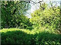
Trackbed of the Midland and South Western Junction Railway, south of Cricklade
The trackbed is on a raised embankment, a few metres east of the traffic-free cycle route that has been created alongside it. The trackbed is virtually hidden beneath the verdant springtime growth. The M&SWJR was created in 1884 by a merger of the Swindon, Marlborough and Andover Railway (SMAR) and the Swindon and Cheltenham Extension Railway (SCER). Despite doing sterling service in two world wars the line fell into decline in the postwar years closing to passenger traffic in 1961. Much more here http://www.swindonsotherrailway.co.uk/
Image: © Brian Robert Marshall
Taken: 3 May 2014
0.10 miles
7
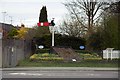
Railway themed flowerbeds
The flowerbeds mark the end of the Swindon & Cricklade Railway. The preservation society based at Blunsdon are planning to extend their line back into Cricklade.
Image: © Steve Daniels
Taken: 14 Apr 2013
0.10 miles
8

Dance Common
The outskirts of Cricklade is known as The Dance. Derived from the old word 'Danskr', meaning Danish, it is thought to refer to the marauding Danes who fought against the Saxons. By the 1800s the common was legally recognised and is now a wildlife protection site, attended to by volunteer groups.
Image: © Neil Owen
Taken: 20 May 2025
0.11 miles
9

Grazing near Cricklade
A small farm has a small collection of livestock.
Image: © Neil Owen
Taken: 20 May 2025
0.11 miles
10
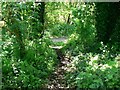
Cycle route 45 from the trackbed of the Midland and South Western Junction Railway, south of Cricklade
The cycle route can be seen at the bottom of the embankment that once carried the much-loved M&SWJR until 1961 when it closed to passenger traffic. Much more about the line here http://www.swindonsotherrailway.co.uk/
Image: © Brian Robert Marshall
Taken: 3 May 2014
0.11 miles