IMAGES TAKEN NEAR TO
Ockwells, SWINDON, SN6 6ED
Introduction
This page details the photographs taken nearby to Ockwells, SN6 6ED by members of the Geograph project.
The Geograph project started in 2005 with the aim of publishing, organising and preserving representative images for every square kilometre of Great Britain, Ireland and the Isle of Man.

There are currently over 7.5m images from over14,400 individuals and you can help contribute to the project by visiting https://www.geograph.org.uk
Image Map (Loading...)


Getting Data...Please wait
Leaflet Map data © OpenStreetMap
Images are licensed for reuse under creativecommons.org/licenses/by-sa/2.0
Notes
- Clicking on the map will re-center to the selected point.
- The higher the marker number, the further away the image location is from the centre of the postcode.
Image Listing (243 Images Found)
Images are licensed for reuse under creativecommons.org/licenses/by-sa/2.0
Image
Details
Distance
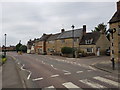
1

Common Hill at the junction of High Street, Cricklade
Image: © David Howard
Taken: 13 Oct 2024
0.03 miles
2
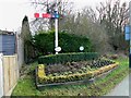
Flowerbed, Purton Road, Cricklade
The flowerbed is sponsored by Blackhorse Contractors, Cricklade Sportsmen's Association and the Swindon and Cricklade Railway. The semaphore railway signal acts as a memorial to the Midland and South Western Junction Railway (M&SWJR) which once the town at this point. The railway crossed Purton Road over an overbridge which has long since been removed. The town's railway station was about 250 metres behind the viewpoint. The B4040 road to Malmesbury follows the route of the line for a few hundred metres. The signal can be seen closer up here Image
Image: © Brian Robert Marshall
Taken: 31 Jan 2011
0.03 miles
3
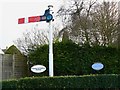
Railway signal, Purton Road, Cricklade
The signal is permanently set at 'stop' and is a reminder that a railway once passed through the town at this point, the former Midland and South Western Junction Railway (M&SWJR). It can be seen in a wider context here Image There is a comprehensive website dedicated to the line here http://www.swindonsotherrailway.co.uk/
Image: © Brian Robert Marshall
Taken: 31 Jan 2011
0.03 miles
4
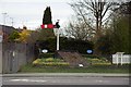
Railway themed flowerbeds
The flowerbeds mark the end of the Swindon & Cricklade Railway. The preservation society based at Blunsdon are planning to extend their line back into Cricklade.
Image: © Steve Daniels
Taken: 14 Apr 2013
0.04 miles
5
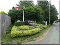
Railway themed floral display on the B4553, Cricklade
On the course of the former railway.
Image: © JThomas
Taken: 11 Jul 2019
0.04 miles
6
South end of High Street, Cricklade, Wiltshire
Image: © Jeff Gogarty
Taken: 9 Aug 2020
0.07 miles
7
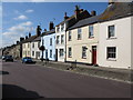
Terraced houses on Cricklade's main street
Image: © Nick Smith
Taken: 27 Sep 2009
0.07 miles
8
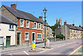
High Street
High Street in Crickalde.
Image: © Wayland Smith
Taken: 25 May 2020
0.07 miles
9
Common Hill, Cricklade
The wall is the back of a block of garages.
Image: © David Howard
Taken: 13 Oct 2024
0.08 miles
10
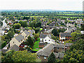
View south from St Sampson's tower, Cricklade
The view shows mostly fairly recent housing south of the church. The road at the left is the B4553 road to Purton.
Image: © Brian Robert Marshall
Taken: 6 Sep 2009
0.09 miles