IMAGES TAKEN NEAR TO
Manor Orchard, SWINDON, SN6 6EA
Introduction
This page details the photographs taken nearby to Manor Orchard, SN6 6EA by members of the Geograph project.
The Geograph project started in 2005 with the aim of publishing, organising and preserving representative images for every square kilometre of Great Britain, Ireland and the Isle of Man.

There are currently over 7.5m images from over14,400 individuals and you can help contribute to the project by visiting https://www.geograph.org.uk
Image Map (Loading...)


Getting Data...Please wait
Leaflet Map data © OpenStreetMap
Images are licensed for reuse under creativecommons.org/licenses/by-sa/2.0
Notes
- Clicking on the map will re-center to the selected point.
- The higher the marker number, the further away the image location is from the centre of the postcode.
Image Listing (399 Images Found)
Images are licensed for reuse under creativecommons.org/licenses/by-sa/2.0
Image
Details
Distance
1
![Cricklade houses [47]](https://s2.geograph.org.uk/geophotos/06/34/85/6348522_02817aa7_120x120.jpg)
Cricklade houses [47]
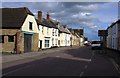
Byrn Cottage, number 14 Calcutt Street is early/mid 19th century and is listed for group value, grade II, with detrails at: https://historicengland.org.uk/listing/the-list/list-entry/1023089
Cricklade is the first town downstream on the River Thames. The town was founded by the Anglo-Saxons in the 9th century at the point where the Roman Ermin Way crosses the River Thames. It is one of the thirty burhs (fortified towns) recorded in the Burghal Hidage document, which describes a system of fortresses and fortified towns built around Wessex by King Alfred. The fortifications have been extensively excavated in several places on all four of its sides.
Image: © Michael Dibb
Taken: 25 Aug 2019
0.03 miles
2
Priory Park Preparatory School, Cricklade
Image: © Jeff Gogarty
Taken: 16 Oct 2021
0.05 miles
3
![Cricklade houses [48]](https://s2.geograph.org.uk/geophotos/06/34/85/6348526_da6cbdb7_120x120.jpg)
Cricklade houses [48]
Number 18 Calcutt Street is 18th century and is listed for group value, grade II, with details at: https://historicengland.org.uk/listing/the-list/list-entry/1284315
Cricklade is the first town downstream on the River Thames. The town was founded by the Anglo-Saxons in the 9th century at the point where the Roman Ermin Way crosses the River Thames. It is one of the thirty burhs (fortified towns) recorded in the Burghal Hidage document, which describes a system of fortresses and fortified towns built around Wessex by King Alfred. The fortifications have been extensively excavated in several places on all four of its sides.
Image: © Michael Dibb
Taken: 25 Aug 2019
0.05 miles
4
![Cricklade houses [49]](https://s0.geograph.org.uk/geophotos/06/34/85/6348528_960be8b5_120x120.jpg)
Cricklade houses [49]
Number 19 Calcutt Street is mid 19th century and is listed for group value, grade II, with details at: https://historicengland.org.uk/listing/the-list/list-entry/1023090
Cricklade is the first town downstream on the River Thames. The town was founded by the Anglo-Saxons in the 9th century at the point where the Roman Ermin Way crosses the River Thames. It is one of the thirty burhs (fortified towns) recorded in the Burghal Hidage document, which describes a system of fortresses and fortified towns built around Wessex by King Alfred. The fortifications have been extensively excavated in several places on all four of its sides.
Image: © Michael Dibb
Taken: 25 Aug 2019
0.05 miles
5

Cotswold Hare Trail, Prior Park School, Cricklade (1)
The Cotswold Hare Trail is an annual event part of the Cirencester March Hare Festival. More below.
Image: © Brian Robert Marshall
Taken: 31 Mar 2017
0.05 miles
6
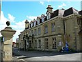
Cotswold Hare Trail, Prior Park School, Cricklade (2)
The Cotswold Hare Trail is an annual event part of the Cirencester March Hare Festival. More below. The building is as seen from the public highway. Grade II listed https://www.historicengland.org.uk/listing/the-list/list-entry/1356093
Image: © Brian Robert Marshall
Taken: 31 Mar 2017
0.05 miles
7
![Cricklade buildings [32]](https://s0.geograph.org.uk/geophotos/06/34/85/6348520_bf996f1b_120x120.jpg)
Cricklade buildings [32]
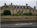
The Manor House was formerly known as The Hermitage as it was said to have been built on the site of a medieval hermitage. The building was erected in the late 19th century but was built in a mid 17th century style. A school since 1946, the building is listed, grade II, with details at: https://historicengland.org.uk/listing/the-list/list-entry/1356093
Cricklade is the first town downstream on the River Thames. The town was founded by the Anglo-Saxons in the 9th century at the point where the Roman Ermin Way crosses the River Thames. It is one of the thirty burhs (fortified towns) recorded in the Burghal Hidage document, which describes a system of fortresses and fortified towns built around Wessex by King Alfred. The fortifications have been extensively excavated in several places on all four of its sides.
Image: © Michael Dibb
Taken: 25 Aug 2019
0.05 miles
9
![Cricklade houses [50]](https://s0.geograph.org.uk/geophotos/06/34/85/6348532_84dce108_120x120.jpg)
Cricklade houses [50]
Number 19A (nearest the camera) and number 20 Calcott Street, seen here, are, along with numbers 21 and 22, the remains of a row of seven houses built in the 1730s to create votes. They stand just outside the walls of the Saxon burgh and were much discussed in the disputed parliamentary election of 1774. There are brief details and links at: https://en.wikipedia.org/wiki/Cricklade_(UK_Parliament_constituency) The row of four houses is listed for historical reasons with details at: https://historicengland.org.uk/listing/the-list/list-entry/1023091
Cricklade is the first town downstream on the River Thames. The town was founded by the Anglo-Saxons in the 9th century at the point where the Roman Ermin Way crosses the River Thames. It is one of the thirty burhs (fortified towns) recorded in the Burghal Hidage document, which describes a system of fortresses and fortified towns built around Wessex by King Alfred. The fortifications have been extensively excavated in several places on all four of its sides.
Image: © Michael Dibb
Taken: 25 Aug 2019
0.07 miles
10
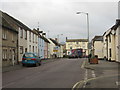
A Cricklade scene
The Yale Hotel dominates the junction at the High Street in the old Saxon town founded on a spot where Romans were thought to have settled on the fledgling River Thames.
Image: © James Denham
Taken: 12 Jan 2012
0.07 miles