IMAGES TAKEN NEAR TO
Latton, SWINDON, SN6 6DH
Introduction
This page details the photographs taken nearby to SN6 6DH by members of the Geograph project.
The Geograph project started in 2005 with the aim of publishing, organising and preserving representative images for every square kilometre of Great Britain, Ireland and the Isle of Man.

There are currently over 7.5m images from over14,400 individuals and you can help contribute to the project by visiting https://www.geograph.org.uk
Image Map (Loading...)


Getting Data...Please wait
Leaflet Map data © OpenStreetMap
Images are licensed for reuse under creativecommons.org/licenses/by-sa/2.0
Notes
- Clicking on the map will re-center to the selected point.
- The higher the marker number, the further away the image location is from the centre of the postcode.
Image Listing (18 Images Found)
Images are licensed for reuse under creativecommons.org/licenses/by-sa/2.0
Image
Details
Distance

2
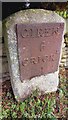
Old Milestone, Latton
On a stretch of the old Ermin Way now bypassed by the A49, which also runs atop the old route of the Thames & Severn Canal. Cricklade iron plate, erected by the Cirencester & Cricklade turnpike trust in the 19th century
Inscription: Cirenᴿ. / 6 / Crickᴰ / 1
Grade II listed Number 1356077 see https://historicengland.org.uk/listing/the-list/list-entry/1356077
Milestone Society National ID: WI_CICK06
Image: © Tom Blanden
Taken: 28 Nov 2022
0.04 miles
3
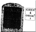
Old Milestone by the A419 near Cricklade
Metal plate attached to stone post by the A419, in parish of Latton (North Wiltshire District), Ermin Way, outside Cotswold Gate, by the road, on South West side of road. Cricklade iron plate, erected by the Cirencester & Cricklade turnpike trust in the 19th century.
Inscription reads:-
CIRENᴿ.
6
CRICKᴱ.
1
Carved benchmark recorded.
Grade II listed.
List Entry Number: 1356077 https://historicengland.org.uk/listing/the-list/list-entry/1356077
Milestone Society National ID: WI_CICK06
Image: © JM Weightmann
Taken: 1 Oct 2000
0.04 miles
4
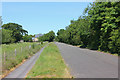
Lane to Latton
Lane linking Cricklade and Latton.
Image: © Wayland Smith
Taken: 25 May 2020
0.10 miles
5
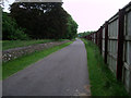
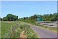
Bridleway alongside the A419
Public bridleway alongside the A419 dual carriageway, separated from it by a wooden fence. This is an access-only road to the former lock cottage next to Latton Basin Image] on the disused Thames & Severn Canal, and to Street Farm on the other side of the dual carriageway, which is reached by a bridge further on.
Image: © Vieve Forward
Taken: 2 Jun 2014
0.12 miles
6
Another hay lot marker and the North Meadow National Nature Reserve, Cricklade
The NNR is of interest all year round but in April it is particularly attractive for its display of snakeshead fritillaries. The land is flat and access is fairly straightforward and this makes it a favourite with visitors of all ages and abilities.
Image: © Brian Robert Marshall
Taken: 22 Apr 2010
0.14 miles
7
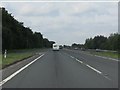
A419 north of Cricklade
The access on the left is the residual northbound connection from Cricklade, left in place when the Latton bypass was constructed. A close look at the area's maps will show that fincding the route between Cricklade and Latton is now something of a brain teaser!
Image: © J Whatley
Taken: 22 Sep 2010
0.15 miles
8

Hay lot marker and the North Meadow National Nature Reserve, Cricklade
The initials on the old marker stone read 'JB'. There is another stone with the same initials a few hundred metres away Image The hedge in the background marks the location of the River Churn. There is a profusion of snakeshead fritillaries this year.
Image: © Brian Robert Marshall
Taken: 22 Apr 2010
0.15 miles
9
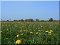
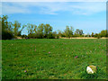
North Meadow National Nature Reserve, Cricklade
The meadow supports a diverse range of flora from the snake's head fritillary to dandelions. The latter are easier to spot in this image than the former.
Image: © Brian Robert Marshall
Taken: 29 Apr 2007
0.16 miles
10
Next to the A419
Lane adjacent to the A419 near Latton.
Image: © Wayland Smith
Taken: 25 May 2020
0.19 miles