
IMAGES TAKEN NEAR TO
The Priory, SWINDON, SN6 6DG
Introduction
This page details the photographs taken nearby to The Priory, SN6 6DG by members of the Geograph project.
The Geograph project started in 2005 with the aim of publishing, organising and preserving representative images for every square kilometre of Great Britain, Ireland and the Isle of Man.

There are currently over 7.5m images from over14,400 individuals and you can help contribute to the project by visiting https://www.geograph.org.uk
Image Map
Images are licensed for reuse under creativecommons.org/licenses/by-sa/2.0
Notes
- Clicking on the map will re-center to the selected point.
- The higher the marker number, the further away the image location is from the centre of the postcode.
Image Listing (228 Images Found)
Images are licensed for reuse under creativecommons.org/licenses/by-sa/2.0
Image
Details
Distance
1
![Cricklade houses [21]](https://s2.geograph.org.uk/geophotos/06/34/56/6345666_0a72c99b_120x120.jpg)
Cricklade houses [21]
Numbers 2 and 3 the Priory are house in the nearer part with the gable to the road. The building is 17th century incorporating some medieval work, the remains of the Hospital of St. John the Baptist, founded for travellers, pre-1231. The outline of the hospital's east window can be seen in the gable. No 3 was refaced in 1809. Listed, grade II, with details at: https://historicengland.org.uk/listing/the-list/list-entry/1284180
Built against the rear of number 3 and facing the road, number 4 The Priory is early 19th century and is listed, grade II, with details at: https://historicengland.org.uk/listing/the-list/list-entry/1356066
Cricklade is the first town downstream on the River Thames. The town was founded by the Anglo-Saxons in the 9th century at the point where the Roman Ermin Way crosses the River Thames. It is one of the thirty burhs (fortified towns) recorded in the Burghal Hidage document, which describes a system of fortresses and fortified towns built around Wessex by King Alfred. The fortifications have been extensively excavated in several places on all four of its sides.
Image: © Michael Dibb
Taken: 25 Aug 2019
0.00 miles
2
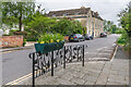
The Priory
Building in two sections dating from the 17th-19th Centuries but incorporating parts of the original Hospital of St John the Baptist, founded before 1231. Grade II listed - see https://historicengland.org.uk/listing/the-list/list-entry/1284180?section=official-list-entry for the nearer (and older) part and https://historicengland.org.uk/listing/the-list/list-entry/1356066?section=official-list-entry for the part beyond.
Image: © Ian Capper
Taken: 2 May 2022
0.00 miles
3
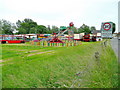
Funfair at Cricklade
The Cricklade Town Fair takes place in June every year.
This fairground is by the High Bridge on the north side of town.
Image: © Jonathan Billinger
Taken: 17 Jun 2009
0.02 miles
4
![Cricklade buildings [9]](https://s2.geograph.org.uk/geophotos/06/34/56/6345670_806ae40c_120x120.jpg)
Cricklade buildings [9]
Thames Hall was built in 1870 as a Wesleyan Chapel. It ceased to be used when the congregation amalgamated with the Primitive Methodists. It became known as the Priory Methodist hall and was used, at times, as an overspill chassroom for the school on the other side of the river.
In 1964, the property was brought by the Trustees of the Cricklade Recreation Club to use for youth activities following the demolition of their hall next to the Town Hall. In 2007 Thames Hall was gifted to Cricklade Town Council by the Trustees and is still mainly used by the local Scout and Guide Groups.
Cricklade is the first town downstream on the River Thames. The town was founded by the Anglo-Saxons in the 9th century at the point where the Roman Ermin Way crosses the River Thames. It is one of the thirty burhs (fortified towns) recorded in the Burghal Hidage document, which describes a system of fortresses and fortified towns built around Wessex by King Alfred. The fortifications have been extensively excavated in several places on all four of its sides.
Image: © Michael Dibb
Taken: 25 Aug 2019
0.02 miles
5

The Thames Hall
Built in 1870 as a Wesleyan Chapel, the congregation later amalgamated with the Primitive Methodists, becoming known as the Priory Methodist hall. When the chapel was declared redundant it was used for other purposes, like an overspill classroom for the ‘bottom’ School on the other side of the River. In 1964 the hall came under the control of the Trustees of the Cricklade Recreation Club to use for youth activities. In 2007, the Thames Hall was gifted to Cricklade Town Council by the Trustees and is still mainly used by the local Scout and Guide Groups.
Image: © Neil Owen
Taken: 20 May 2025
0.02 miles
6
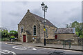
Thames Hall
Former Methodist chapel by Town Bridge, now a community hall.
Image: © Ian Capper
Taken: 2 May 2022
0.02 miles
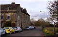
9

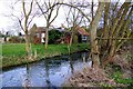
Town Bridge, Cricklade
Short stone bridge crossing the fledgling river in "the first town on the Thames". It is obviously strong enough to take heavy traffic.
https://crickladetowncouncil.gov.uk/
Image: © Colin Smith
Taken: 16 Jul 2009
0.03 miles
10
![Cricklade features [2]](https://s1.geograph.org.uk/geophotos/06/34/56/6345653_68a815c2_120x120.jpg)
Cricklade features [2]
Town Bridge carries High Street over the River Thames. There has probably been a bridge at this spot since the 9th century but the existing one was rebuilt in 1852 as is recorded by the stone panels above the arch. Listed, grade II, with details at: https://historicengland.org.uk/listing/the-list/list-entry/1023113
Cricklade is the first town downstream on the River Thames. The town was founded by the Anglo-Saxons in the 9th century at the point where the Roman Ermin Way crosses the River Thames. It is one of the thirty burhs (fortified towns) recorded in the Burghal Hidage document, which describes a system of fortresses and fortified towns built around Wessex by King Alfred. The fortifications have been extensively excavated in several places on all four of its sides.
Image: © Michael Dibb
Taken: 25 Aug 2019
0.03 miles