
IMAGES TAKEN NEAR TO
Gas Lane, SWINDON, SN6 6BY
Introduction
This page details the photographs taken nearby to Gas Lane, SN6 6BY by members of the Geograph project.
The Geograph project started in 2005 with the aim of publishing, organising and preserving representative images for every square kilometre of Great Britain, Ireland and the Isle of Man.

There are currently over 7.5m images from over14,400 individuals and you can help contribute to the project by visiting https://www.geograph.org.uk
Image Map
Images are licensed for reuse under creativecommons.org/licenses/by-sa/2.0
Notes
- Clicking on the map will re-center to the selected point.
- The higher the marker number, the further away the image location is from the centre of the postcode.
Image Listing (474 Images Found)
Images are licensed for reuse under creativecommons.org/licenses/by-sa/2.0
Image
Details
Distance
1

Gas Lane, Cricklade
The name gives a clue: this used to be the site of the town gasworks in the past. Cricklade relied on coal gas, which was produced and stored in a holder in the nineteenth and into the twentieth centuries. With the old works now cleared, modern housing stands in its place. However, a local man who has lots of knowledge related that the house at the far end with red tiling was the old works governor's property. He also spoke of the lane being used to drive cattle through on market days.
Image: © Neil Owen
Taken: 20 May 2025
0.00 miles
2
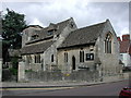
Cricklade St Mary, Wiltshire
A medieval church, it became one of the first in England to be given back to the Roman Catholic Church after it became redundant.
Image: © ChurchCrawler
Taken: 30 Aug 2004
0.02 miles
5
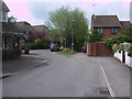
Gas Lane, Cricklade
Modern housing estate at the end of Gas Lane. A footpath runs alongside it.
Image: © Vieve Forward
Taken: 30 Apr 2014
0.05 miles
7
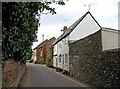
Old and new housing in Gas Lane
There is no Electric Alley in Cricklade, but it does have a Gas Lane. This is one of several narrow and old lanes, off Cricklade's High Street. The old cottages are followed by modern houses.
Image: © P L Chadwick
Taken: 26 Sep 2010
0.05 miles
8
![Cricklade buildings [7]](https://s0.geograph.org.uk/geophotos/06/34/34/6343492_77fcb320_120x120.jpg)
Cricklade buildings [7]
Number 49a and 49b High Street are two shops although 49b seemingly has revered to a dwelling.
Cricklade is the first town downstream on the River Thames. The town was founded by the Anglo-Saxons in the 9th century at the point where the Roman Ermin Way crosses the River Thames. It is one of the thirty burhs (fortified towns) recorded in the Burghal Hidage document, which describes a system of fortresses and fortified towns built around Wessex by King Alfred. The fortifications have been extensively excavated in several places on all four of its sides.
Image: © Michael Dibb
Taken: 25 Aug 2019
0.05 miles
9
![Cricklade buildings [6]](https://s2.geograph.org.uk/geophotos/06/34/34/6343490_212907e0_120x120.jpg)
Cricklade buildings [6]
Number 48 High Street is home to a coffee shop.
Cricklade is the first town downstream on the River Thames. The town was founded by the Anglo-Saxons in the 9th century at the point where the Roman Ermin Way crosses the River Thames. It is one of the thirty burhs (fortified towns) recorded in the Burghal Hidage document, which describes a system of fortresses and fortified towns built around Wessex by King Alfred. The fortifications have been extensively excavated in several places on all four of its sides.
Image: © Michael Dibb
Taken: 25 Aug 2019
0.06 miles
10
![Cricklade buildings [5]](https://s1.geograph.org.uk/geophotos/06/34/34/6343489_8e1ee59f_120x120.jpg)
Cricklade buildings [5]
The Ancient Raj is housed in a modern building at number 47 High Street.
Cricklade is the first town downstream on the River Thames. The town was founded by the Anglo-Saxons in the 9th century at the point where the Roman Ermin Way crosses the River Thames. It is one of the thirty burhs (fortified towns) recorded in the Burghal Hidage document, which describes a system of fortresses and fortified towns built around Wessex by King Alfred. The fortifications have been extensively excavated in several places on all four of its sides.
Image: © Michael Dibb
Taken: 25 Aug 2019
0.06 miles