IMAGES TAKEN NEAR TO
High Street, SWINDON, SN6 6BX
Introduction
This page details the photographs taken nearby to High Street, SN6 6BX by members of the Geograph project.
The Geograph project started in 2005 with the aim of publishing, organising and preserving representative images for every square kilometre of Great Britain, Ireland and the Isle of Man.

There are currently over 7.5m images from over14,400 individuals and you can help contribute to the project by visiting https://www.geograph.org.uk
Image Map (Loading...)


Getting Data...Please wait
Leaflet Map data © OpenStreetMap
Images are licensed for reuse under creativecommons.org/licenses/by-sa/2.0
Notes
- Clicking on the map will re-center to the selected point.
- The higher the marker number, the further away the image location is from the centre of the postcode.
Image Listing (436 Images Found)
Images are licensed for reuse under creativecommons.org/licenses/by-sa/2.0
Image
Details
Distance
1
![Cricklade buildings [4]](https://s1.geograph.org.uk/geophotos/06/34/34/6343485_dcdd27b9_120x120.jpg)
Cricklade buildings [4]
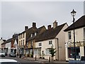
This fine house, number 44 High Street, is late 18th or early 19th century with a 20th century shop front on the ground floor. Listed, grade II, with details at: https://historicengland.org.uk/listing/the-list/list-entry/1183092
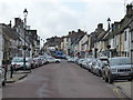
Cricklade is the first town downstream on the River Thames. The town was founded by the Anglo-Saxons in the 9th century at the point where the Roman Ermin Way crosses the River Thames. It is one of the thirty burhs (fortified towns) recorded in the Burghal Hidage document, which describes a system of fortresses and fortified towns built around Wessex by King Alfred. The fortifications have been extensively excavated in several places on all four of its sides.
Image: © Michael Dibb
Taken: 25 Aug 2019
0.00 miles
2
![Cricklade houses [1]](https://s2.geograph.org.uk/geophotos/06/34/34/6343486_d652f509_120x120.jpg)
Cricklade houses [1]
Number 45 High Street was built in the 18th century, was converted to a shop and has now reverted to a dwelling. Listed, grade II, with details at: https://historicengland.org.uk/listing/the-list/list-entry/1183098
Cricklade is the first town downstream on the River Thames. The town was founded by the Anglo-Saxons in the 9th century at the point where the Roman Ermin Way crosses the River Thames. It is one of the thirty burhs (fortified towns) recorded in the Burghal Hidage document, which describes a system of fortresses and fortified towns built around Wessex by King Alfred. The fortifications have been extensively excavated in several places on all four of its sides.
Image: © Michael Dibb
Taken: 25 Aug 2019
0.00 miles
4
![Cricklade buildings [1]](https://s2.geograph.org.uk/geophotos/06/34/34/6343482_3a9cd02f_120x120.jpg)
Cricklade buildings [1]
London House, number 41 High Street, is late 17th century. The shop front was inserted in the early 19th century and two rear extensions were added at the same time. Listed, grade II, with details at: https://historicengland.org.uk/listing/the-list/list-entry/1023103
Cricklade is the first town downstream on the River Thames. The town was founded by the Anglo-Saxons in the 9th century at the point where the Roman Ermin Way crosses the River Thames. It is one of the thirty burhs (fortified towns) recorded in the Burghal Hidage document, which describes a system of fortresses and fortified towns built around Wessex by King Alfred. The fortifications have been extensively excavated in several places on all four of its sides.
Image: © Michael Dibb
Taken: 25 Aug 2019
0.01 miles
5
![Cricklade buildings [2]](https://s3.geograph.org.uk/geophotos/06/34/34/6343483_757d66b4_120x120.jpg)
Cricklade buildings [2]
Number 42 High Street is 20th century and currently houses a cafe.
Cricklade is the first town downstream on the River Thames. The town was founded by the Anglo-Saxons in the 9th century at the point where the Roman Ermin Way crosses the River Thames. It is one of the thirty burhs (fortified towns) recorded in the Burghal Hidage document, which describes a system of fortresses and fortified towns built around Wessex by King Alfred. The fortifications have been extensively excavated in several places on all four of its sides.
Image: © Michael Dibb
Taken: 25 Aug 2019
0.01 miles
6
![Cricklade buildings [3]](https://s0.geograph.org.uk/geophotos/06/34/34/6343484_0cb3b181_120x120.jpg)
Cricklade buildings [3]
Number 43 High Street houses a fish and chip shop.
Cricklade is the first town downstream on the River Thames. The town was founded by the Anglo-Saxons in the 9th century at the point where the Roman Ermin Way crosses the River Thames. It is one of the thirty burhs (fortified towns) recorded in the Burghal Hidage document, which describes a system of fortresses and fortified towns built around Wessex by King Alfred. The fortifications have been extensively excavated in several places on all four of its sides.
Image: © Michael Dibb
Taken: 25 Aug 2019
0.01 miles
7
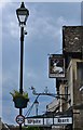
Cricklade High Street: The White Hart Inn
Image: © Michael Garlick
Taken: 19 May 2017
0.01 miles
8
Cricklade, Wiltshire
The White Hart Hotel is on the left. I took some views of Cricklade and completely forgot to post them.
Image: © Chris Allen
Taken: 21 May 2016
0.01 miles
10
![Cricklade houses [2]](https://s0.geograph.org.uk/geophotos/06/34/34/6343488_3d596796_120x120.jpg)
Cricklade houses [2]
Number 46 High Street is a former hall house of the late 15th or early 16th century and is timber framed behind the cladding. The hall has a first floor and staircase inserted in the 17th century. The attic retains the original roof structure largely unaltered. Listed, grade II, with much detail at: https://historicengland.org.uk/listing/the-list/list-entry/1356063
The house was being renovated in 2010 when P L Chadwick took this image of the house Image
Cricklade is the first town downstream on the River Thames. The town was founded by the Anglo-Saxons in the 9th century at the point where the Roman Ermin Way crosses the River Thames. It is one of the thirty burhs (fortified towns) recorded in the Burghal Hidage document, which describes a system of fortresses and fortified towns built around Wessex by King Alfred. The fortifications have been extensively excavated in several places on all four of its sides.
Image: © Michael Dibb
Taken: 25 Aug 2019
0.01 miles