IMAGES TAKEN NEAR TO
Bath Road, SWINDON, SN6 6AX
Introduction
This page details the photographs taken nearby to Bath Road, SN6 6AX by members of the Geograph project.
The Geograph project started in 2005 with the aim of publishing, organising and preserving representative images for every square kilometre of Great Britain, Ireland and the Isle of Man.

There are currently over 7.5m images from over14,400 individuals and you can help contribute to the project by visiting https://www.geograph.org.uk
Image Map (Loading...)


Getting Data...Please wait
Leaflet Map data © OpenStreetMap
Images are licensed for reuse under creativecommons.org/licenses/by-sa/2.0
Notes
- Clicking on the map will re-center to the selected point.
- The higher the marker number, the further away the image location is from the centre of the postcode.
Image Listing (380 Images Found)
Images are licensed for reuse under creativecommons.org/licenses/by-sa/2.0
Image
Details
Distance
1
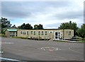
St. Sampson's Church of England Schools, Bath Road
There is both a junior school and an infants' school on this site. The school was originally built in 1959, and took children from 5 to 11 years old. Because of the expansion of Cricklade, the school was divided into two in 1979. It was also necessary in the 1970's to add mobile classrooms, of which this would appear to be one. The schools are now spread across several buildings, of which this of course is just one.
Image: © P L Chadwick
Taken: 26 Sep 2010
0.02 miles
2
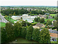
View north-north-west from St Sampson's tower, Cricklade
The primary subject of this image is St Sampson's C of E Primary School. The road is Bath Road.
Image: © Brian Robert Marshall
Taken: 6 Sep 2009
0.03 miles
3
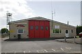
Cricklade Fire Station
Cricklade Fire Station, Bath Road, Cricklade, Wiltshire
Image: © Kevin Hale
Taken: 8 May 2007
0.04 miles
4
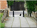
Path and Cat, St Sampson's Church, Cricklade
The path leads to the church behind the viewpoint. The cat is a friendly little thing or perhaps he just knew I'm a cat person.
Image: © Brian Robert Marshall
Taken: 6 Sep 2009
0.04 miles
5
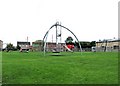
Recreation ground (1), Bath Road
This recreation ground for children, has been provided with various items of play equipment to keep them amused. However the Fire Station drill tower in the background is not one of them!
Image
Image: © P L Chadwick
Taken: 26 Sep 2010
0.04 miles
6
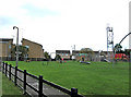
Recreation ground (2), Bath Road
Another view of this recreation ground, located between the Parish Church and the Fire Station.
Image
Image: © P L Chadwick
Taken: 26 Sep 2010
0.04 miles
7
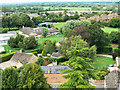
View north from St Sampson's tower, Cricklade
At left is part of St Sampson's C of E Primary School.
Image: © Brian Robert Marshall
Taken: 6 Sep 2009
0.04 miles
8
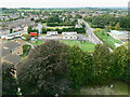
View west-north-west from St Sampson's tower, Cricklade
The complex in the centre is Cricklade Fire Station. Behind the fire station is what looks like 1970s local authority housing.
Image: © Brian Robert Marshall
Taken: 6 Sep 2009
0.04 miles
9
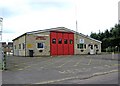
Cricklade Fire Station, Bath Road
The fire service in Wiltshire comes under Wiltshire Fire & Rescue Service, whose HQ is at Potterne, near Devizes. The Cricklade Fire Station was opened in 1963, the same year, by co-incidence, when Cricklade Railway Station finally closed to freight traffic; the passenger service having ceased in 1961.
Image
Image: © P L Chadwick
Taken: 26 Sep 2010
0.04 miles
10
![Cricklade features [11]](https://s3.geograph.org.uk/geophotos/06/34/79/6347935_030533d1_120x120.jpg)
Cricklade features [11]
Limestone orthostatic wall, probably early to mid 19th century. Three very broad stones and 13 others with occasional ties form a wall about 1.3 metres high around the front garden of The Gatehouse.
Cricklade is the first town downstream on the River Thames. The town was founded by the Anglo-Saxons in the 9th century at the point where the Roman Ermin Way crosses the River Thames. It is one of the thirty burhs (fortified towns) recorded in the Burghal Hidage document, which describes a system of fortresses and fortified towns built around Wessex by King Alfred. The fortifications have been extensively excavated in several places on all four of its sides.
Image: © Michael Dibb
Taken: 25 Aug 2019
0.05 miles