IMAGES TAKEN NEAR TO
High Street, SWINDON, SN6 6AB
Introduction
This page details the photographs taken nearby to High Street, SN6 6AB by members of the Geograph project.
The Geograph project started in 2005 with the aim of publishing, organising and preserving representative images for every square kilometre of Great Britain, Ireland and the Isle of Man.

There are currently over 7.5m images from over14,400 individuals and you can help contribute to the project by visiting https://www.geograph.org.uk
Image Map (Loading...)


Getting Data...Please wait
Leaflet Map data © OpenStreetMap
Images are licensed for reuse under creativecommons.org/licenses/by-sa/2.0
Notes
- Clicking on the map will re-center to the selected point.
- The higher the marker number, the further away the image location is from the centre of the postcode.
Image Listing (423 Images Found)
Images are licensed for reuse under creativecommons.org/licenses/by-sa/2.0
Image
Details
Distance
1
The Happy Buddha Thai Restaurant, 8 Bath Road
Located just behind the Vale Hotel.
Image: © P L Chadwick
Taken: 26 Sep 2010
0.00 miles
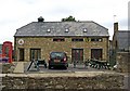
2
![Cricklade buildings [25]](https://s2.geograph.org.uk/geophotos/06/34/79/6347950_5302fd40_120x120.jpg)
Cricklade buildings [25]
This 18th century house has a 19th century shop front. Listed, grade II, with details at: https://historicengland.org.uk/listing/the-list/list-entry/1356098
https://historicengland.org.uk/listing/the-list/list-entry/1023079
Cricklade is the first town downstream on the River Thames. The town was founded by the Anglo-Saxons in the 9th century at the point where the Roman Ermin Way crosses the River Thames. It is one of the thirty burhs (fortified towns) recorded in the Burghal Hidage document, which describes a system of fortresses and fortified towns built around Wessex by King Alfred. The fortifications have been extensively excavated in several places on all four of its sides.
Image: © Michael Dibb
Taken: 25 Aug 2019
0.00 miles
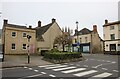
3
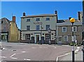
The Vale Hotel, 32 High Street
It was originally The White House (not to be confused with The White Hart, or The White Lion, both of which are still open). It was a staging inn during the 18th century, and a posting house in the earlier part of the 19th century. During that century it was rebuilt. In the late 1890's it was renamed The Vale Hotel. Possibly this was because it was popular with members of the Vale of the White Horse Hunt. Today it describes itself as an inn and restaurant.
The Vale Hotel's location is at the junction of High Street, Calcutt Street (in the foreground) and Bath Road (on the immediate left of the hotel). As can be seen, the entrance to Bath Road is very narrow, and it is no longer a through road, having been replaced by a road built in the 20th century.
Image
Image: © P L Chadwick
Taken: 23 May 2010
0.01 miles
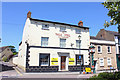
4
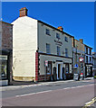
The Vale Hotel, 32 High Street
The road on the left of the Vale Hotel is Bath Road, Interestingly there are no windows on this side of the building. On the High Street frontage, there is a bracket, from which a sign must at one time have hung. Outside is the well-known clock, put here in 1897 to celebrate Queen Victoria's Diamond Anniversary. She had become Queen in 1837, and died in early 1901.
Image
Image: © P L Chadwick
Taken: 23 May 2010
0.01 miles
5
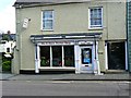
His-N-Hairs, High Street, Cricklade
A feature of some tonsorial establishments is a name that involves a play on words. This might not be the most original to be seen but the proprietors are to be applauded for at least trying.
Image: © Brian Robert Marshall
Taken: 31 Mar 2017
0.01 miles
6
![Cricklade buildings [26]](https://s1.geograph.org.uk/geophotos/06/34/79/6347957_045f1bc4_120x120.jpg)
Cricklade buildings [26]
This early 19th century building, The Vale Hotel, would appear to have closed recently. The boards on either side of the front door are advertising a Thai restaurant at the rear of the hotel. The hotel was formerly known as the White Horse Inn. Listed, grade II, with details at: https://historicengland.org.uk/listing/the-list/list-entry/1023099
Cricklade is the first town downstream on the River Thames. The town was founded by the Anglo-Saxons in the 9th century at the point where the Roman Ermin Way crosses the River Thames. It is one of the thirty burhs (fortified towns) recorded in the Burghal Hidage document, which describes a system of fortresses and fortified towns built around Wessex by King Alfred. The fortifications have been extensively excavated in several places on all four of its sides.
Image: © Michael Dibb
Taken: 25 Aug 2019
0.01 miles
7
![Cricklade features [13]](https://s3.geograph.org.uk/geophotos/06/34/79/6347963_5326e9da_120x120.jpg)
Cricklade features [13]
A plaque on the front of The Vale Hotel - see Image
Cricklade is the first town downstream on the River Thames. The town was founded by the Anglo-Saxons in the 9th century at the point where the Roman Ermin Way crosses the River Thames. It is one of the thirty burhs (fortified towns) recorded in the Burghal Hidage document, which describes a system of fortresses and fortified towns built around Wessex by King Alfred. The fortifications have been extensively excavated in several places on all four of its sides.
Image: © Michael Dibb
Taken: 25 Aug 2019
0.01 miles
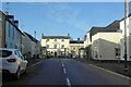
8
Calcutt Street, Cricklade
At the junction of High Street
Image: © David Howard
Taken: 13 Oct 2024
0.01 miles
9
The Vale Hotel
Disused pub and hotel in Cricklade.
Image: © Wayland Smith
Taken: 25 May 2020
0.01 miles
10
Calcutt Street and The Vale Hotel, Cricklade
The hotel is on the High Street. It is a grade II listed building, early 19th century.
Image: © Robin Webster
Taken: 9 Jan 2022
0.01 miles